BIM plus the power of cloud-enabled technology fosters innovative projects
Do you find yourself saying things would be better “if only…”? You could have a better design, a shorter schedule, or be more profitable, if only you could have X or if only Y existed. It’s time to start removing “if only” from your vocabulary; all of your wishes are possible now. Autodesk solutions help make the art of the possible a reality.
Are you and your firm still designing and building the way you’ve always been doing things? It’s time to consider moving away from old workflows and processes unnecessary that can result in lost time and profits and increased project risk. Design isn’t a linear process; it requires the input of multiple stakeholders consecutively and sometimes with little notice. The industry is trending towards collaborative design as a best practice, even instituting contracting methods to force collaboration, and away from working in silos. Technology continues to advance at an increasing pace, with the aim to assist designers, stakeholders, contractors, etc. in overcoming barriers to collaboration, minimizing schedule issues, and improving profitability. It is innovative and new, but it’s also what makes sense for improving project design, construction, and management. Today’s technology solutions are not your dad’s CAD. It’s not even your older sister’s CAD anymore.
Capture
In the last few years, the barrier to entry for Reality Capture has become almost non-existent. As of January 2017, over 670,000 drones have been registered with the FAA. Previously, it cost $40k to have one aerial site survey done. Now, firms can buy a drone and survey software for $1.5k and use it for the lifetime of the drone, not just once on one site. Laser scanners now cost only a fraction of what they did ten years ago and weigh a fraction of what they did. For example, Leica’s new BLK360 costs only $16,000 and weighs 2 lb. compared to the Leica model from 2007 which cost $80,000 and weighed 24 lb. Firms and individuals can more easily implement one or multiple of these photogrammetry and LiDAR devices into their practice and don’t need to rely solely on survey firms and governmental departments anymore. Sites can be captured, easily, many times during the project and after the handover.
OWNERS IN THE DRIVER’S SEAT: STRATHCONA COUNTY
In response to their consultants’ lack of experience and understanding of point cloud functionality, Strathcona County adopted the reality capture workflow internally. They are working with and educating consultants on new projects on how to use this cloud data to their mutual benefit.
Located near Edmonton in Alberta, Canada, surveying becomes a challenge in Strathcona County during the snowy months of the year. To mitigate the number of times they’d need to visit a site, the County started referring to the data they captured. They then moved into using scanning and ReCap for multiple purposes, such as determining the height of power lines, calculating excavation necessary to accommodate double-decker buses in a facility built for articulated buses, and identifying low spots on a skating rink. The consultants were able to bring the point clouds into Autodesk modeling software to perform measurements and seeing there was more capacity for added value from the workflow, the County added photogrammetry to their scans.
The County currently working on a major roadway upgrade for several intersections along Sherwood Drive. As there are many businesses along the route being upgraded, public engagement is a crucial component of the project. To that end, the County took a very detailed scan with the intent to use if for visualization in addition to engineering design. The scans of the businesses were imported into the InfraWorks model, including signage and storefronts. With local landmarks and real life building facades, business owners can easily figure out where they are and determine the impact of the project on their property. Several of the businesses will be more heavily impacted due to road closures and lane expansions. The County was able to visually show the impact of changes like adding a road where there is currently a drive-through for a business.
The scan also allowed for feature extraction of the power poles down the roadway. The County had access to the data of what exactly is already there, without having to manually survey, which would have taken exponentially more time. And, data of existing buried public utilities could be added within the InfraWorks model.
The County has plans to incorporate their lessons learned and expand the workflow on future projects. A bridge rehab project is in the pipeline and the County is excited to see what they can do with reality capture on a project like that.
SHORT SCHEDULE, SMALL BUDGET: BOGERUD FITNESS PARK

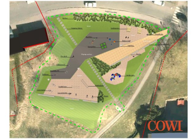
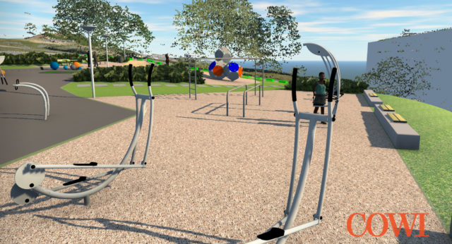
The City of Oslo plans to build a new, 2,300-square-meter outdoor fitness park in the City’s Bogerud neighborhood. Instead of a prefab equipment and plans, the City asked COWI AS to do a feasibility study and provide preliminary costs for a custom park design that would appeal to the residents of the neighborhood, as well as be environmentally sustainable.
The project and budget were small limiting resources to just one staff. The design was simplified by taking photogrammetry and LiDAR capture and bringing the project into ReCap. In mere hours, AutoCAD Civil3D and InfraWorks were used to create a model of the area’s existing conditions. Using this existing context, a 3D model was created of the proposed design.

In less than a week, COWI AS was able to deliver the project—including cost estimates, earthwork calculations, and high-quality project visualizations. This project was possible in the limited timing and budget allocated, only due to technology, reality capture workflows, and in-context visualization.
Read the full story.
Model
Once the existing conditions have been brought into Autodesk software, such as Recap360, it can then be brought into complex modeling software. Complex modeling software, such as InfraWorks, will open your possibilities to the unlimited. Not only can it process massive amounts of data, it can quickly create unlimited design iterations through generative design. Use the cloud to power this generative process to produce results in moments, rather than hours or days. Cloud based modeling allows for quick feedback from project stakeholders.
BIG DATA: INTERCITY SØRLI-BRUMUNDDAL
Technology solutions are crucial for the success of projects small and large; however, it’s especially apparent in large infrastructure projects. Rambøll Sweco ANS leveraged Autodesk technology to make a project to lay 75 kilometers of double track between Sørli and Brummunddal successful. The large 3D model required a powerful software solution that could aggregate huge amounts of disparate data and at the same time present this data and the proposed design alternatives in an easy to view and understand format.
Using InfraWorks, Rambøll optimized new, existing, and abandoned routes for economic and environmental gains. They also designed three separate corridor alternatives through the city of Hamar. The model assisted the team in predictive analysis of the alternatives. The model could be influenced to answer questions such as “What if I make this change?”; “How long will it take if…?”; “How much earthworks need to be removed?”; or “What if I have to fix…?”, informing the stakeholders of the potential cost of each alternative.
Read the full story.
PLANNING FOR FLYING CARS: MOBILITY SIMULATION
Densification of the population into urban environments, rapid adoption of ridesharing, and development of autonomous vehicles (for ground and air) cannot be ignored. While we aren’t as far from the age of the Jetson’s as we once were, the future is here and we have to plan and design for it. Transportation projects are often lengthy in schedule from start to completion, which means that they need to be designed for future needs, rather than current needs, maybe even for flying cars in a near future. No matter the type of transport, a mobility simulator, such as Mobility Simulator for InfraWorks, can show how people in various types of transport interact within a fully multimodal analysis.
An airport is a prime example of multiple modes of modality intersecting, from transit getting to the airport to moving around inside the airport. Planning efficient routes that consider the type of traffic flow specific to an airport and moving passengers into and through the building is a challenge. InfraWorks’ Mobility Simulator can address flow of traffic in the arrivals and departures area, including handicap access, valet parking, express trains into the terminal buildings, and passenger unloading and loading of buses. It can also help visualize crowd control and queuing in areas such as the check-in counters and security and baggage screening.
PROJECT COLLABORATION IN THE CLOUD: PORTLAND INTERNATIONAL AIRPORT

Collaboration is the key to any project’s success then and now. Autodesk has focused on creating technology that enhances collaboration through cloud access. BIM 360 Team, formerly A360 Team, is a single source for project communication, collaboration, and design, instantly up-to-date for all project stakeholders. The cloud allows anytime, anywhere access. For example, urgent questions can be reviewed and answered without having to wait for team members to return to the office and look at plans located on a local server.
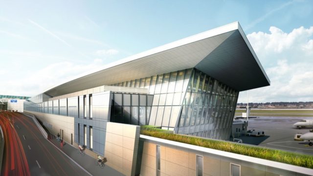
The Portland International Airport (PDX) Terminal Balancing project is being delivered as a collaborative design partnership between Fentress Architects, headquartered in Denver, Colorado and Hennebery Eddy Architects based out of Portland, Oregon. Fentress and Hennebery Eddy worked together as one single design team, enabled by BIM360 Team, to best utilize the strengths of both firms to deliver a complex public infrastructure project for the Portland International Airport.
Hennebery Eddy Architects and Fentress Architects used BIM360 Team and Collaboration for Revit to centralize their two design teams in the cloud. Communication, design reviews, file sharing, version history tracking and model coordination was all done using A360, eliminating the need to physically co-locate the two offices.
Read the full story.
CONSTRUCTION GOES VIRTUAL: NDOT BRIDGE
Reality capture is not just for project initiation, it is a useful tool during the construction phase of the project as well. As drones can be flown on an on-demand basis with just a UAV pilot’s license, instead of contracting a surveyor to do occasionally site surveys through construction, construction progress can be monitored on a much more finite timeline, from daily to hourly. Utilizing UAV data or a laser scan can remove the need to have personnel capturing data or inspecting hazardous areas. You can capture conditions from a safe distance.
The Nevada Department of Transportation (NDOT), in conjunction with Autodesk, is using a UAV to capture site condition and construction progress. The project involves a bridge being constructed over the existing terrain and then excavating the dirt from underneath the bridge. Reality Capture is helping NDOT monitor construction progress of the bridge and the greater road project, as well as decreasing risk on the construction site. Reality Capture allows you to easily and quickly capture changing site conditions through comparison modeling and create a visual log of construction progress.
Manage
Reality capture can also aid in delivering high-value as-built models/verifications at project handover. Redlines on a blueprint aren’t as valuable as a dynamically updated model. In other words, current conditions from a capture always trumps as-builts that should be called as-designed. Reality capture is a great tool for documenting construction and improve what is delivered to the owner. Not only do you get visual information, but it complements the model, with more accurate spacing and dimensions of the installation throughout the process and after handover.
Reality capture is also a great way to monitor a site or facility against the original capture. The scanning process, with either LiDAR or photogrammetry, makes it easy to take continual scans for comparison purposes, making it easier to monitor change. Additionally, it can decrease on-site risk through a workflow that mitigates personnel safety. Instead of taking in-person measurements, a UAV or LiDAR can capture the measurements, removing the risk factors.
THE CONFLUENCE OF CAPTURE MODEL MANAGE: GLEN CANYON DAM
The US recently had a taste of what the catastrophic effects would be should a National Critical Infrastructure (NCI) site fail with Oroville Dam crisis. Autodesk is working with the Bureau of Reclamation to create a process of capturing the existing conditions, making a model, and monitoring and managing its assets. Glen Canyon Dam, located upriver from Hoover Dam and of the same dimensions, is a categorized as National Critical Infrastructure. It manages the flow of the River into Lake Mead, which in turn is what Hoover Dam uses to create hydroelectric power. Lake Mead is extremely low, meaning that Hoover is almost at the point where it can’t generate power which has serious far-reaching effects, like on providing power for Las Vegas.
Glen Canyon Dam was designed in the 1950s, before the age of CAD not to mention BIM. It was the last of the major dams that the Bureau built along the Colorado River. While the Bureau maintains the facility, the Department of Homeland Security manages it and all other NCI sites.
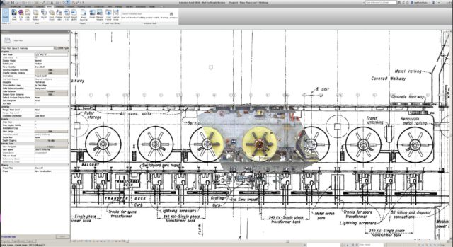
Autodesk and the Bureau are using the capture, model, manage methodology to create a dynamic model the Bureau can use to monitor the ever-changing conditions at the Dam and project outcomes of different potential events. In the interior of the dam, a UAV—drone—was flown and captured the 8 hydroelectric generators. This capture was imported into Revit and overlaid on the original blueprints.

Since drones weren’t allowed to be flown outside the Dam, a helicopter was used to capture the exterior of the Dam through photogrammetry. SONAR was used to capture underwater conditions.
The capture of the Dam allowed us to create a model and the model allows us to do anything, only limited by our imagination. Based on visualization, simulation, and analysis (VSA) tools in the Autodesk portfolio, in the words of an Autodesk engineer, we could even model a scenario where Godzilla visits the Dam.
The model is intended to aid in management of the Dam. It can contribute to:
- O&M
- Security /SA (situational awareness)
- Facilities Management
- Education/Outreach
- Change Detection
Change detection was an unexpected benefit of the capture, model, manage methodology. The Bureau can capture the Dam and compare the output with the initial capture and use the changes between the two to monitor what is going on with the Dam like if things are moving, expanding, or contracting. InfraWorks can be used as Information Management System an (IMS) to monitor this process over time.
Read the full story.
Capture, model, manage, and…[insert your possibility here]
While the capture, model, manage workflows are still being adopted, technology continues to evolve. Current technology trends focus on improving efficiency, predictability, and resiliency aligns with owners awarding bids based on best value rather than best price.
Soon, owners will expect what is currently considered innovative as a baseline requirement for their projects. So, what will be innovative in the future? It may not be flying cars or hover boards, but it will involve the cloud and the interconnectedness of the Internet of Things (IoT). We’ll see more telemetry and sensors on dams, bridges, and roads, resulting in smart assets. Smart assets are possible now. Have you incorporated the IoT or any other workflows that are in the art of the possible?

Learn More about the Dynamic Duo for Civil Design, AutoCAD Civil 3D and Infraworks