& Construction

Integrated BIM tools, including Revit, AutoCAD, and Civil 3D
& Manufacturing

Professional CAD/CAM tools built on Inventor and AutoCAD
10 min read
As surveyors, our “foresight” is the last reading taken before changing the instrument to the next position. It is something our profession has done for over 4700 years dating back to the Egyptians, the first practicing professional land surveyors. While the ”backsight”, our look back along a line of progress, has always been our known point, it also signifies our impending intent to move forward; to extend our line of progress from that known position to one of the unknown, the “foresight”. Today that word has an even more importance for our profession as we look forward, extending our line of professional progress somewhat into the unknown as the pace of technology disrupts how we approach our craft.
The practice of land surveying is “any service or work, the adequate performance of which involves the application of special knowledge of the principles of mathematics, the related physical and applied sciences and the relevant requirements of law for adequate evidence to the act of measuring and locating lines, angles, elevations, natural and man-made features in the air, on the surface of the earth, within underground workings, and on the beds of bodies of water for the purpose of determining areas and volumes, for the monumenting of property boundaries and for the platting and layout of lands and subdivisions of land, including the topography, alignment, and grades of streets and for the preparation and perpetuation of maps, record plats, field note records and property descriptions that represent these surveys.”
Merriam-Webster defines foresight as “an act or power of foreseeing: an act of looking forward.” If you Google it what pops up is a business definition “the ability to predict or the action of predicting what will happen or be needed in the future.” Very appropriate.
While new technology has greatly reduced a project’s completion time, it has also created several challenges including that technology keeps changing, at a rate faster than some of us can keep pace with. This means that surveyors will need to develop new competencies and workflows to optimize the now constant flow of information to deliver a better service to their clients.
In the short term this will affect the profession via a ‘drinking from a fire hose’ scenario. The fact that our profession is one of the most technically enabled within the infrastructure professional ecosystem means we will be one of the most technologically advanced professions in the world. However, success here is defined by proactive efforts, not reactive.

The constant state of disruption, due to ever increasing rate of digital technology development, deployment and adoption, is not likely to slow down any time soon. Reimagining what surveying will be, we must work to understand how this disruption will impact how we plan, design, build, operate, and maintain our infrastructure and, by extension, the surveyor’s role in that process. How do we run our businesses, attract the best and brightest talent into the profession, and stay relevant and competitive? Surveyors, as key professionals involved in all development phases, must look at the changes in our built environment and think about how the following trends impact me and my business:
I suspect the first thing that comes to mind is “What? Wait a minute? Why no mention of say new laser scanning platforms, new GNSS/GPS solutions, UASs/drones, reality capture & computing and other technology that surveyors are now using or should be using for surveying?” My answer to this is simple. 40 years ago, surveyors were still measuring distances by pulling tape and elevations with stadia rods. I remember when the first Red Mini’s came out to replace steel tapes. Since then, EDMs, robotic total stations, laser scanners, drones, and a whole host of other tools have arrived. However, they are still focused on helping us capture data faster, more accurately, and making our jobs more efficient. Incredibly important, but no longer the full story. Remember “the ability to predict or the action of predicting what will happen or be needed in the future.”

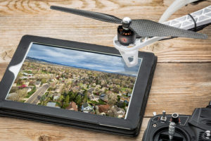
Going forward, we need to think beyond just the latest way to capture information and more about how will it be used and who should be the curators of that captured information. Today surveying is beginning to be augmented by UAS/drones or construction stakeout automated with iPads integrated into total stations. Although, yes, in the end, we still stamp plans. The big change that is important for us to understand is less about the tool and more about the value of what we captured–data.
The sheer volume and importance of data, coupled with the rapid rise in need for real time, connected, up-to-date, accurate, and precise information derived from that data is driving a whole new industrial revolution (the 4th) and business ecosystem. That is something we all need to keep in our sights and think to ourselves “How do we stay relevant as the built environment gets converted into its digital twin in the cloud.”
Surveying is “the application of special knowledge of the principles of mathematics, the related physical and applied sciences and the relevant requirements of law for adequate evidence to the act of measuring and locating lines, angles, elevations, natural and man-made features.” among other things. An example of our new role as curators of the built environment information centers on man-made features, big data, analytics, security, and the like, under the guise of critical infrastructure protection. It involves bringing all our data capture knowledge and tools (total stations, laser scanners, drones, underwater UAVs/sonar etc) in a “Scan to BIM” approach for a very real modern need, digitalization of infrastructure.
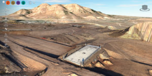
The Glen Canyon Dam, Hoover Dams ‘little’ brother, provides both power and water to a majority Western United States. Located in northern Arizona on the Colorado River, the 710-foot high dam produces five billion kilowatt-hours of hydroelectric power per year. The dam itself forms Lake Powell which covers more than 250 square miles.

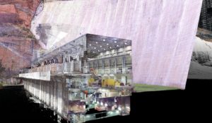
Built 50 years ago by the U.S. Bureau of Reclamation (USBR) using mostly 2D engineering drawings, today, their goal is to modernize and virtualize as much of that dam as possible in an integrated data fusion approach developing a unified intelligent 3D model of the dam and power plant facility. This digital twin (image shown to the left) of the physical world was created in three weeks, from survey to model. The model will be added to and used going forward for design, operation, and management, asset management & monitoring, public outreach, education activities, and, most importantly, security, given it is deemed a critical national infrastructure asset. Think of all the other types of built infrastructure out there, public or private, that need a similar conversion. Who better to drive this approach to ensure accuracy and precision of that information than surveyors.

When we look back over the work surveyors have done in “the preparation and perpetuation of maps, record plats, field note records and property descriptions that represent these surveys,” many times that record plat was the completion of the project for us. In today’s digital world there is so much more that can be done and surveyors should be considering this. The resulting assets of infrastructure project comes with a multiple decade long commitment to operations and maintenance. Ensuring, after construction, the exact result is documented and used as the benchmark for its operation is critical. The process of integrating accurate and precise as-built survey data into a BIM model and having that digital twin tied into a large-scale asset management information model is critical if that BIM data is to be used once the asset is operational. These modern digital plans of record afford owners and even cities critical information regarding their assets, especially when made available to their departments. That information can be regularly recaptured and compared for tracking changes.
This brings us to the topic about digital information and cities. While much has been written about smart cites, I would argue smart cities come from smart planning. A ‘smart’ city is one that uses the data they have to make work easier, life better, access faster, and foster community engagement. The first step is leveraging the big data of what exists, where it is located, and what is its condition. The integration of survey data, GIS, and sensor devices is, for owners, the game changer. Data is no longer static, but can be streamed, consumed, and analyzed in real time. Sensor based data collection and transmission is not new, but was often just unstructured at best. Today the ability to harness the location component of the data transmitted against the accurate and precise digital base map of a city’s infrastructure assets will unlock so much more. That location based data fusion process is something surveyors should be key stakeholders in.
Whether driven by the need to make a smart city, or simply the city and its built assets smarter, this push to the digitalization of the built environment is accelerating. In many cases, cities and their departments now have deeper budgets for GIS system and data capture for big data analytics. The collection and aggregation of infrastructure information for use in powerful modeling and analysis solutions starts on the ground, with GPS, laser scanning, UAV/drones, and the like, being tools all surveyors now need to consider as standards of practice going forward.
One thing we have always known is that location is an integral and critical part of all data especially when dealing with our built environment. The need to integrate many location-based data sources of existing conditions into a BIM model will continue to rise. Those who take the initiative to up-skill to be the purveyors of this information in this ‘era of connection’ will see a long runway of work ahead.
“The practice of land surveying is “any service or work, the adequate performance of which involves the application of special knowledge of the principles of mathematics, the related physical and applied sciences…” Special knowledge of the principles of mathematics, related physical and applied sciences has been the foundation for what we as surveyors do. We have always been and will never stop being learners and innovators. From compass and tape to transits, and onto robotic one person total stations and laser scanners, from hand drafting to CAD to BIM/modeling, and from sun shots to GPS to GNSS, we have always reimagined how to execute our profession as disruptive technology emerged onto the scene. While our core charter is to locate, certify, and map three dimensional points on surface of the earth, the information we collect is now much more important in its digital form, in a world where location drives almost everything.

Today anyone with a cellphone has a camera and GPS. If you have a drone, you have a personalize aerial mapping and photogrammetry system that can not only capture ortho imagery but calculate volumes. It is the surveyors who must step up and lead as experts in accurate, precise, and certified digital twins of the physical world. The ability to fly a dam or a hundred-acre project site or scan miles of highways off the back of a truck, all to create 3D models within hours to a few days, accurate to 5-10mm, means surveying is being reimagined. The question arises – will surveyors take a leadership role in the development of new technologies and processes or will we react to technological advances that continue to come from outside the surveying profession?
Whether field crew, party chief, managers, or survey firm owners, we must make the transition yet again to remain both relevant to the new digital age but more so continue as guardians of “determining areas and volumes, for the monumenting of property boundaries and for the platting and layout of lands and subdivisions of land, including the topography, alignment, and grades of streets and for the preparation and perpetuation of maps.” So, when you hear things like big data, IoT, Critical Infrastructure Protection, or smart cities, pay attention; that is opportunity calling.
By clicking subscribe, I agree to receive the AEC newsletter and acknowledge the Autodesk Privacy Statement.
Success!
May we collect and use your data?
Learn more about the Third Party Services we use and our Privacy Statement.May we collect and use your data to tailor your experience?
Explore the benefits of a customized experience by managing your privacy settings for this site or visit our Privacy Statement to learn more about your options.