Opening up new economic opportunities for the Malaysian State of Sarawak
Design and construction teams in Malaysia are using Autodesk BIM solutions—including Civil 3D, Revit, ReCap, InfraWorks, Map 3D, Dynamo, 3ds Max, and Navisworks—to deliver the expansion and upgrade of the Pan Borneo Highway Sarawak.
Malaysia’s Ministry of Works is in the midst of a major effort to expand and upgrade the Pan Borneo Highway in the state of Sarawak on the northern coast of Borneo. The project will connect the highway to the adjoining state of Sabah and reduce travel times throughout Sarawak while opening new economic opportunities for the state.
Currently, Sarawak’s major highway system is mainly a 2-lane single carriageway and is notorious for its poor condition in some sections. The two-phase project will upgrade the highway to a 4-lane dual carriageway and extend the highway to 1,060 km. The project also entails the construction of many bridges for river crossings and pedestrian bridges, as well as interchanges and bus shelters all along the length of the highway.
The project began in 2015 and the construction of phase 1, which spans 765 kilometers, is currently underway. The completion of phase 1 is scheduled for mid-2021. The second phase, which will upgrade the portion of the highway in Sabah, is in the planning stage.

Aggressive timelines and massive coordination
Given its large scope, the project was divided into 11 separate sections and work packages—each one stretching between 60 to 90 kilometers. To meet the short timeline for delivery, the construction of all 11 contracts has to be carried out simultaneously.
As such, the overall project requires significant coordination of (and between) 11 different designs and 11 different construction projects. In addition, the designs of all the highway sections had to be coordinated with the existing conditions of the current highway and surrounding landscapes. And the efforts of the extended project team must be coordinated as well, including the client, the 20 firms that secured construction work contracts, and many more subcontractors and consultants.
With this extraordinary level of coordination, it would be very difficult to meet the project’s aggressive timeline using traditional 2D project delivery. Therefore—and in keeping with the Malaysian government’s efforts to streamline and modernize the country’s construction industry—BIM is being used throughout the project.
Integrated BIM project delivery
An integrated software platform of GIS and Autodesk BIM and reality capture solutions supports the development and upgrade of the Pan Borneo Highway Sarawak. The integration of these technologies is helping project stakeholders:
- minimize errors and discrepancies during design,
- manage construction efforts to mitigate risk, and
- create as-built models and a centralized data system for operations and maintenance.
Project modeling
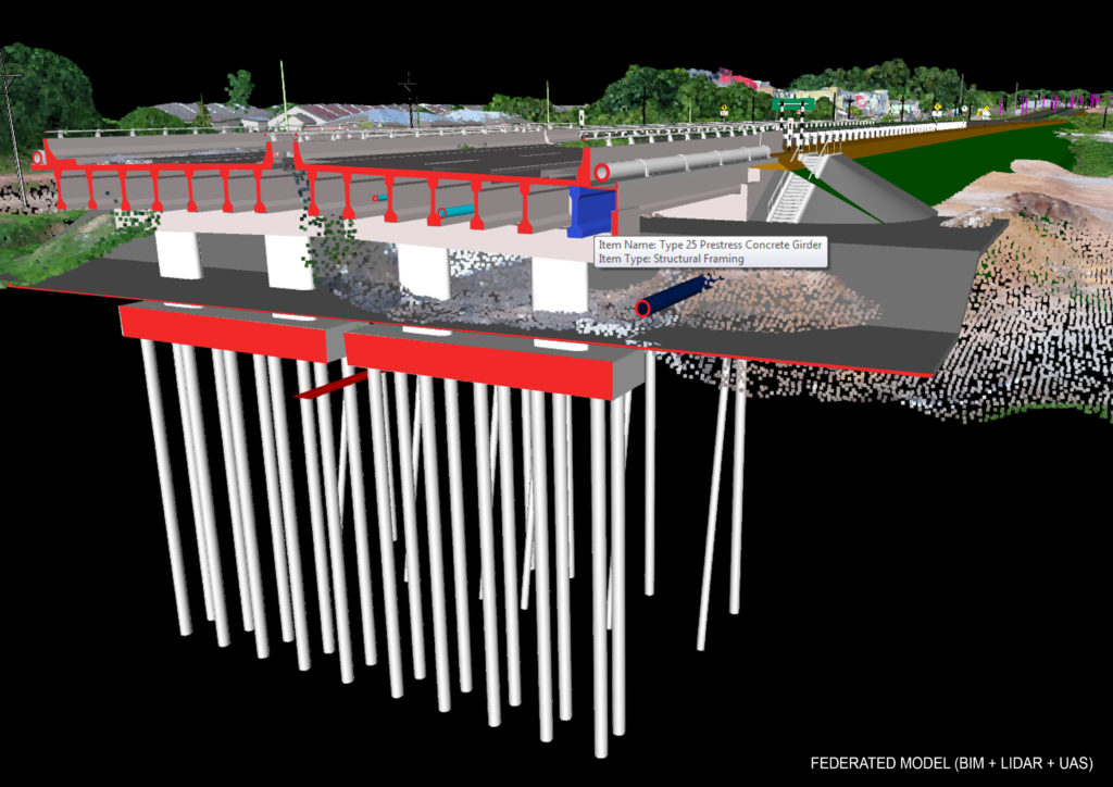
During design, the project teams used ReCap to convert point cloud data that captured existing conditions of the highway and its environs by stationary LiDAR and drone photogrammetry. InfraWorks was used to generate high-quality 3D model renderings and animations during preliminary design stages. The link between Autodesk solutions and GIS data helped inform the design team throughout their efforts.
Civil 3D was used for the detailed design of the highway. The software helped them create custom cross-sections subassemblies that automatically adjusted to updated model terrain information. Revit was used to design the project’s structures and its mechanical & electrical systems. Dynamo enabled them to generate parametric scripts to extend the modeling capabilities of both Civil 3D and Revit.
The project team now uses Navisworks to combine models of different formats into a single project model. This model/platform enables 3D clash detection and 4D construction planning and simulation—giving the team a better understanding of projects issues.

Results
The Pan Borneo Highway Sarawak is Malaysia’s first transportation project to fully embrace the use of BIM and its complementary technologies. The project’s overall construction is approximately 35 percent complete and the use of BIM is generating exciting results for the Malaysian construction industry.
- Routine clash detections and the ability to compare design information to actual site conditions before the start of construction is reducing design discrepancies and rework costs.
- Model-based coordination and communication is helping stakeholders better understand design and construction issues—leading to improved decision-making and quicker resolution.
- A shared, common data environment helps stakeholders gather, collect, and share the latest project information.
- Model-based project scheduling and asset information provides better visibility for all stakeholders, and will be vital for efficient operation and maintenance management.
Digitalization in infrastructure is inevitable. Pan Borneo Highway Sarawak is ‘history in the making’ as it is the first infrastructure project in Malaysia to utilize BIM, GIS and UAS technologies. It is the benchmark for BIM infrastructure projects in Malaysia. BIM ensures project delivery whilst not compromising on cost, time and quality. BIM enables a paradigm shift in the construction industry.
–Dato’ Sri Zohari Akob, Secretary General, Ministry of Works Malaysia