As you might be aware, Autodesk has partnered with Esri, the global leader in geographic information system (GIS) technology, to unite BIM and GIS for driving digital transformation across the AEC industry. Through this partnership, our integrated BIM and GIS solutions bring together design, construction, and asset information with location intelligence and spatial analysis.
By combining the power of BIM and GIS, project and operations teams can better understand where and how assets fit within the context of the natural and built environments. The results are powerful, accurate, and information-rich models with geospatial context for supporting connected planning, design, and construction workflows, resilient asset operations, and improved capital planning.
In this post, we’ll walk through some background about our partnership with Esri and explore three practical workflows for how you can utilize ArcGIS GeoBIM alongside your Autodesk Construction Cloud tools. To start, let’s dive into the benefits of our BIM and GIS cloud collaboration.
BIM and GIS cloud collaboration: Powered by Autodesk Construction Cloud and ArcGIS
The way projects are planned, engineered, constructed, and maintained is changing thanks to our BIM and GIS cloud collaboration. With teams increasingly distributed, they require cloud-based access to connected design and construction information.
The platform connection between Autodesk Construction Cloud and Esri’s ArcGIS enables information-rich design models and geospatial data to be viewed holistically. Owners, AEC managers, and operations teams can explore accurate design details and collaborate on projects of any size with real-world context thanks to this growing interoperability.
By providing a cloud-to-cloud platform connection, coordination, communication, and decision-making throughout the entire project and asset life cycle improves. ArcGIS puts BIM and CAD data in the context of geography, transforming project design, delivery, and management across various industries like AEC, transportation, water, and utilities.
The integration between Autodesk Construction Cloud (ACC) and ArcGIS Online allows for the seamless integration of BIM (Building Information Modeling) and GIS (Geographic Information Systems) data, providing a comprehensive and unified view of project information. With ACC, project teams can manage construction workflows, documents, and models in a cloud-based environment, ensuring that information is accessible and up-to-date. Meanwhile, ArcGIS Online offers robust spatial analysis and visualization tools that help in understanding the geographic context of construction projects.
A crucial component of this integration is Autodesk Docs, part of the Autodesk Construction Cloud, which serves as a common data environment (CDE) for design and construction information. Autodesk Docs provides a centralized platform for storing, organizing, and managing all project documentation, ensuring that all stakeholders have access to the latest information. This common data environment enhances collaboration by reducing information silos, minimizing errors, and ensuring that everyone is working from the most current project data.
By integrating ACC with ArcGIS Online, users can overlay BIM data on geographic maps, enabling a richer analysis of site conditions, environmental impact, and infrastructure planning. This integration facilitates real-time data sharing and collaboration, improving decision-making processes and enhancing project outcomes. Teams can visualize their projects in a geospatial context, identify potential issues early, and coordinate more effectively across different stages of the construction lifecycle. Ultimately, the ACC and ArcGIS Online integration empowers construction professionals to deliver projects more efficiently, sustainably, and with greater precision. But let’s pause for a moment, just what can you do with ArcGIS and ArcGIS GeoBIM?
What is ArcGIS and ArcGIS GeoBIM?
Esri’s ArcGIS is a comprehensive geospatial platform and the leading GIS technology. It provides world-leading capabilities for creating, managing, analyzing, mapping, and sharing all types of data, including:
- Mapping: Understand data in a new way by mapping and visualizing it in 2D, 3D, and real time. Leverage location services and advanced cartographic tools.
- Spatial analytics: Perform spatial modeling and analysis with data from any source, enriched by geography. AI-infused workflows power advanced analytics.
- Field operations: Empower teams to work in disconnected environments. Streamline field data collection and workforce planning, routing, and management.
- Data editing and management: Implement a reliable system of record for data editing, offline data management, and data sharing across an organization.
- Imagery and remote sensing: Leverage an end-to-end system for imagery collection, management, and processing, enhanced by AI workflows.
ArcGIS meets all modern criteria for enterprise-ready technology. It is cloud-based, with a reliable development life cycle, support for standards and specifications, and integration with common IT systems and infrastructure.
Now that we understand the capabilities of ArcGIS, let’s explore what you gain with ArcGIS GeoBIM.
What is Esri’s ArcGIS GeoBIM?
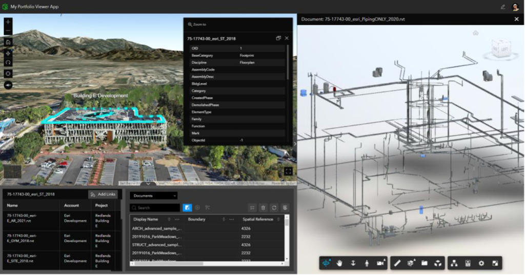
Esri’s ArcGIS GeoBIM offers a connected view across project portfolios for teams to collaborate and explore BIM models, documents, and issues in geospatial context. Powered by ArcGIS, it is an easy-to-use, cloud-to-cloud solution that simplifies how teams view, manage, and share project information between platforms by dynamically linking to data at its source.
With ArcGIS GeoBIM, AEC and owner-operator teams can make better decisions by securely accessing up-to-date project and asset management information—including 3D digital models, documentation, issues, field maps, and reality capture content. Easily connect to and reuse content in Autodesk Construction Cloud to configure and share ArcGIS GeoBIM apps without the need for custom, one-off solutions.
With some background out of the way about our partnership and ArcGIS and ArcGIS GeoBIM, it becomes pertinent to discuss practical and applicable workflows for leveraging these tools alongside your Autodesk products.
Integrated workflows for putting ArcGIS GeoBIM to use alongside Autodesk tools
Design coordination between ArcGIS GeoBIM and ACC
Projects create a lot of design data that must be coordinated for unified deliverables that are constructable and align submissions standards and requirements. As projects progress, this data can become siloed, outdated, and hard to find, which can lead to costly errors, delays, and rework.
ArcGIS GeoBIM links BIM projects and workflows in the Autodesk Construction Cloud with relevant spatial context data in ArcGIS. Project managers can automatically link Autodesk documents with georeferenced GIS features to simplify how teams access, visualize, and query project documentation on an easy-to-use, map-based interface.
Project managers can then easily configure web apps using this linked data to meet the specific needs of every project stakeholder. Sharing ArcGIS GeoBIM apps for improved communication and collaboration is as simple as providing a URL. Teams and clients can then review and provide feedback on relevant information in any web browser, avoiding the need for installed desktop software.
By linking to accurate and up-to-date information in Autodesk Docs, ArcGIS GeoBIM delivers a web-based experience for teams to coordinate design models prior to building them. This enables project teams to detect spatial clashes, mitigate environmental impacts, and address potential risks before construction begins.

Construction planning and coordination
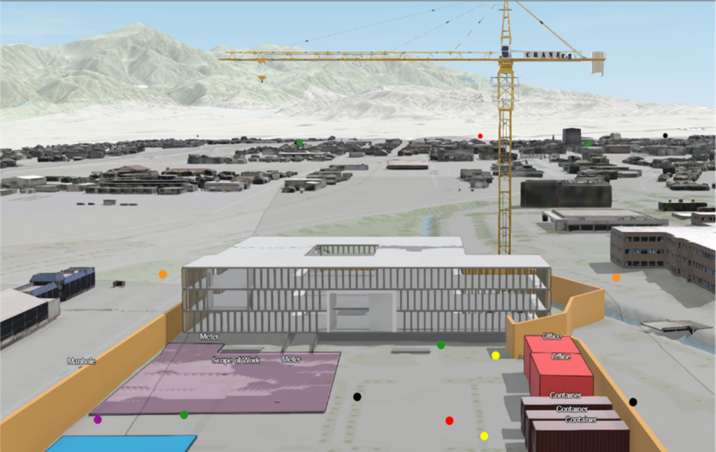
Project managers can use ArcGIS GeoBIM to create a visual representation of the construction site from start to finish for improving planning and coordination.
Choose from dozens of standard 3D symbols for adding to notes, such as cranes, vehicles, and barriers—or add custom symbols to meet your needs. This is useful for designating survey areas where existing utility assets exist before excavation for ensuring streamlined on-site coordination. These easily recognizable symbols enhance understanding of the site and communication among project stakeholders.

Use built-in 3D analysis widgets to easily see work sites and planning scenarios in context to environmental factors, including weather conditions, daylight, shadows, and sight lines. This can improve conversations on safety coordination, egress planning during emergencies, and the placement of equipment and crews during severe weather events.
ArcGIS GeoBIM offers a tool that automatically generates elevation profiles along routes to help teams understand site conditions without traveling to the field. Before construction, teams can identify steep inclines posing vehicle or logistics hazard and plan the best route for accessing assets in difficult terrain before arriving on-site.

Issue management with ArcGIS GeoBIM and Autodesk Construction Cloud
Knowing how projects are progressing and where outstanding issues exist is paramount to achieving successful outcomes. Configurable dashboards in ArcGIS GeoBIM use linked project data for monitoring and analyzing progress, while pinpointing the location of problems and areas of concern. These dashboards can be used for issue reporting, allowing project managers to locate, filter, and drill into issues by status and type on a map.
ArcGIS GeoBIM has capabilities for improving BIM and GIS collaboration between the office and the field on projects and assets. This adds value to all phases of the project lifecycle from planning, design, and construction into asset and facility operations. Teams can easily access accurate information in the field while staying on top of site logistics and accelerating issue turnaround.
With field maps enabled, project managers can collect issues and observations from the field. They can verify collected issues in ArcGIS GeoBIM and make edits when needed. When ready, reviewed issues are easily uploaded to linked documents in Autodesk Construction Cloud and resolved.
Using the ArcGIS Field Maps mobile app available for iOS and Android devices, field workers can create issues and notes with GPS coordinates or by simply pointing to a location on the field map. They can also access an expressive mobile map of the project site and the latest BIM documents and issues from Autodesk Construction Cloud when connected.

In addition to issues that highlight problems or areas of concern, ArcGIS GeoBIM also provides tools for capturing comments from stakeholders to be considered, discussed, or informed. These notes are GIS features and can be linked to documents in Autodesk Construction Cloud. In this way, all data stays connected, up-to-date, and in geographic context for more effective collaboration and deeper understanding between project stakeholders.
Learn more about BIM and GIS collaboration
If the workflows we discussed in this blog sound applicable to your use case, there’s a few helpful links that can help you investigate further. First, you might need some more background about why and how Esri are working together. You can discover more about the Autodesk and Esri partnership for bridging the gap between BIM and GIS on our joint landing page. Additionally, if you want to get started with ArcGIS, you can do that by visiting Esri’s website.
The workflows we’ve discussed in this blog are indicative of the strength gained when we can deliver further interoperability not just within the Autodesk ecosystem, but also in connection with Esri’s suite of tools.