When the Diego Cuê Dam ruptured in the town of Caarapó deep in the southern tip of Brazil, it wasn’t only flooding that the authorities had to manage.
The dammed lake, located in the Ayrton Senna Park, is an important recreation space for residents and is perhaps Caarapó’s only tourist attraction. The flooding of the lake therefore had major financial, social, and environmental consequences.
The town sought a comprehensive overhaul of the dam to restore the lakeside, but it needed confidence in the accuracy of the new design to avoid costly construction rework.
Sparse public resources require smart allocation
With just over 30,000 residents, Caarapó had limited funds from tax collection and few resources to expend on innovation, but key infrastructure such as the drainage system, sanitation, and water supply needed improvement.

In 2015, during the rainy season, all of these factors combined to contribute to an overtopping failure, as the water level exceeded the height of the dam and caused a rupture that flooded the surrounding Ayrton Senna Park, making it inaccessible.
Two years later, civil engineering firm Schettini Engenharia was tasked with designing a new dam using conventional 2D methodologies, Schettini Engenharia launched a company dedicated to innovation in urban infrastructure development, including the use of Building Information Modelling (BIM).
With this specialist experience, Schettini Engenharia revisited the Diego Cuê dam project and recognized the need for strategic partners with expertise in BIM and Geographic Information System (GIS) technologies, including critical water infrastructure software from Autodesk.
Led by Fernando Figueiredo, a civil engineer and BIM specialist, the team created a holistic BIM and GIS solution that allowed them to test dam designs for safety and effectiveness well before the construction phase.

“Small towns face a lot of challenges, especially here in Brazil, when it comes to innovating in public management and obtaining new technologies to improve life for their population,” says Figueiredo. “The BIM solution we proposed improves how infrastructure projects are executed and operated, supporting Caarapó in making more informed decisions about how to spend scarce public resources.”
This digital solution also made it easier to review design models and monitor project execution, enabling more sustainable construction and maintenance practices that would reduce costs and labor and bringing the dam restoration within the limits of town resources.
Streamlining their design phases
Saving time and costs were key aspects of the project solution, which the project engineers organized into four disciplines:
- Geometry
- Earthmoving
- Drainage
- Architecture
One reason to divide the work up like this was to help them decrease the processing required for each design file and streamline adjustments.
They designed the key structures of cofferdams, overflow channels, access roads, and the emergency spillway in each of these disciplines, with data shortcuts between models to quickly generate elements based on what had already been designed. They drew drainage pipes with Civil 3D Pipe Network tools and developed architectural structures in Revit.
These 3D BIM models were based on the existing 2D plans by Schettini Engenharia and contextually enhanced with rainfall and water flow data, geotechnical data on soil and groundwater conditions, and topography surveying. The Geotechnical Modeler in Civil 3D helped to visualize and analyze geotechnical data, including 3D visualizations of boreholes on top of the surface generated by the survey.
BIM Manager Matheus Lima de Barros established project management workflows and defined BIM uses, team roles, and software standards to ensure interoperability between different tools – another critical benefit of the project solution.
“Many tests were done to ensure the interoperability of the required information, especially the workflows that we noticed presented the biggest challenges,” says de Barros.

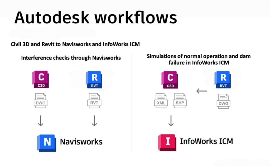
For example, the team performed interference checks by importing design models into Navisworks. They found inconsistencies in some slope extensions, the positioning of the overflow pipe, and the location of certain pipe connections. These were corrected before generating the designs for execution, eliminating significant rework in the construction phase to save on costs and time.
Modeling scenarios based on weather data
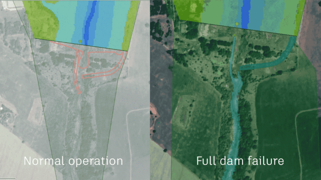
For a dam break analysis that would help identify vulnerabilities, the final topography surface, pipes and spillway structure were exported from Civil 3D to InfoWorks ICM to run flood simulation scenarios.
To define accurate dam break scenarios in InfoWorks ICM, Autodesk Systems Engineer Ryan Brown imported shapefiles from Civil 3D and surfaces from Civil 3D and Infraworks to create updated surface models with contextual detail.
The dam itself was represented by a base linear structure object and the main outlet structure by a pipe and sluice gate, according to dimensions from the previous 2D plans. Regional hydrological inflow data between 1974-2009 was used to inform how the dam could perform given different rainfall and groundwater flows – that is, whether it would risk overtopping or failure.
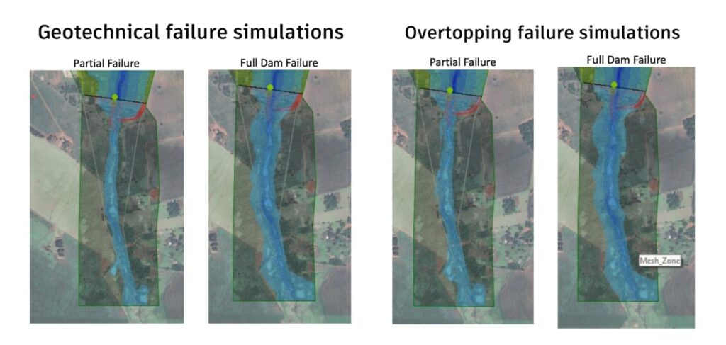
During the normal rainfall period, the model showed that the dam would operate normally. Then the team created four scenarios to analyze the impact of a storm. Leveraging water flow data describing a typical storm, the first two scenarios simulated the dam if it were to fail – either partially or completely – due to water stress on surrounding soil and rock based on rising water levels in the dam lake. The second two simulated how the dam could fail when the water surface flowed over the top of the dam – either partially or fully.

“With all of these simulations and the background imagery layer, I was able to see what areas would be inundated and if any adverse effects would take place,” says Brown. “The good news is, none of these simulations really showed any kind of catastrophic downstream effect on structures or anything that looked important based on that visual feedback.”
In other words, the simulations confirmed that the new dam design would protect the Aryton Senna Park in the event of storms and flooding.
AR dazzles during design reviews
Visualizing the project model was a vital step in the design review, and the team ambitiously presented the design in augmented reality with the help of 3D BIM software Unity Reflect Review, with users being able to visualize an accurate 3D model over the real-world site on their smartphones, providing a clearer understanding of object behavior in the construction space and giving stakeholders greater security and confidence in the design.
“The choice to use Unity Reflect Review to review was the icing on the cake of our project,” says BIM Analyst Newton Caxeta. “It delivers a 3D model that stakeholders can view from all angles, giving an advanced technology experience that computer visualization alone cannot provide.”
Smart city engineering also works in small towns
Construction on the dam began in June 2022, and InfoWorks ICM allowed the team to design effective drainage and perform simulations to confirm the safety and reliability of the new dam prior to construction.
Supported by BIM methodologies in cloud documentation, modelling, mapping design processes and overall project management, this not only improved the design of the Diego Cuê dam, it streamlined construction by significantly reducing errors and rework.
The result was a meaningfully shortened project timeline with much-appreciated cost savings.
The project also established a new precedent for smart city engineering in Caarapó, forging a path for how BIM and Autodesk tools can be used to make crucial improvements to the town’s water infrastructure.
“Using this dam project as a foundation, we plan to apply similar methodologies to improving the drainage, sewer and water supply systems in Caarapó,” says Schettini Engenharia’s Figueiredo. “Using the Autodesk ecosystem, we can make every city a smart city with better BIM solutions and stronger data for improved public services.”
Wading deeper into the Autodesk ecosystem
They’ve begun extending beyond that foundation by utilizing Autodesk’s Info360 Asset SaaS application, which is designed to track and manage the assets for their developing drainage network, sewer system, and water distribution network.
As they noted during a class they taught to other water professionals at Autodesk University, “Using InfoWorks ICM gave us confidence that we were on the right track, as we were able to perform the most severe simulations to ensure the safety of this new dam. Moreover, quick and easy interoperability with Autodesk AEC Collection solutions resulted in less turnaround time than expected.”
The Diego Cuê dam project illustrates the workflow benefits in validating the quality of water solutions using tools such as InfoWorks ICM, benefits that make critical water infrastructure improvements more feasible for resource-strapped regions.