Are you an Info360 Asset user? If you work for a water utility or are a consultant for utilities, chances are high that you regularly collaborate with people who rely heavily on Esri products. Our latest release gives you a way to add significant value to their work by pushing your in-depth data and analysis to them, helping them find new efficiencies and make important decisions.
Push your CCTV data to ArcGIS Online
We’ve been adding options for our customers to do more with their Info360 Asset data in prior releases, and this one is a big one, giving you the ability to push new data feeds like pipe inspection and observation layers with defect conditions to ArcGIS Online dashboards. Integrating your Info360 Asset data like this can help your field crews more easily identify and locate underground asset defects found by CCTV video inspections.
For example, if you push your pipe inspection data into ArcGIS Online, field workers will be able to immediately see all the details of your processed video footage, helping them more quickly determine how many and which underground assets are defective, ensuring that always know where to dig – or not to dig.
One of our Info360 power users, GHD Associate Todd Plank, a location intelligence professional with many years of experience navigating the complexities of GIS, location intelligence, and asset management, has been trying out these new integrations.
“Autodesk and Esri are bringing the pieces of the puzzle together, providing my clients with powerful tools and collaborative interfaces to analyse the important data needed for making informed decisions about the assets they manage,” says Plank. “With Info360 Asset, we have the tools to efficiently manage the volumes of CCTV inspection data and perform risk and rehabilitation analysis for capital improvement planning.”
Incorporating and extending CCTV data is one of the best use cases for Info360 Asset, which also recently began integrating VAPAR CCTV AI recognition capabilities. Info360 Asset’s web-based interface is designed to be easy for field workers to use, allowing them to simply drag and drop their CCTV recordings into their browser’s Info360 Asset interface, which processes the data speedily in the cloud, only uploading files that have associated records, weeding out any duplicates.

“The ability to provide an interface for field inspectors to drag and drop their data and media directly into the Info360 platform is creating efficiencies, allowing us to quickly rerun models and identify infrastructure needs that require attention, along with the associated project budgets,” says Plank.
A refreshing way to stay up to date
Integrations like these with online services like ArcGIS Online, which are powered by APIs just like Info360 apps are, will become increasingly important as the water industry adopts more and more SaaS and cloud-based technologies. Over time, legacy providers of desktop-only based software may have trouble keeping up with this trend, partly because keeping apps synced with APIs is a service in itself, but the reward that an integration like this brings to users is substantial.

Consider the alternative. Nearly all water professionals know that being able to export flat files via open file formats and import them into complementary apps and services is handy and convenient, but they have probably also learned the hard way that keeping them synced or performing a scheduled syncing workflow via scripting isn’t 100% reliable. Difficulties like this is why we’ve just released a Refresh Layers button.
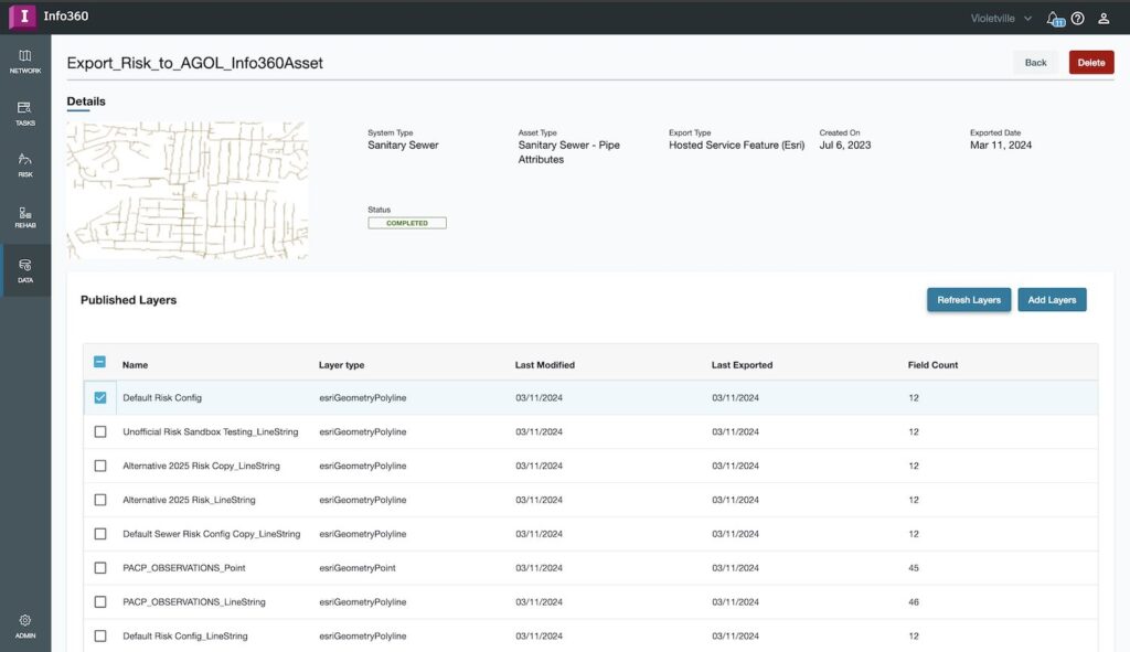
Now, for example, after you’ve set up an export for inspection layers to ArcGIS Online, you’ll see a Refresh Layers button next to the Add Layers button in your list of Published Layers. You can push that button any time you want to sync your data. You can validate it yourself after refreshing a layer by choosing the “View in ArcGIS” option, which will open an ArcGIS Online window in your browser.
Extending the benefits of Info360 Asset to the enterprise
What is powerful about this Esri integration is that it gives you the ability to extend your use of Info360 Asset. All the hard work you do crunching numbers and finding advanced efficiencies with your analysis can now be spread to the rest of the enterprise.
Many water professionals currently use ArcGIS Online to manage and view their GIS data and share with their organisation. In fact, Esri says that over 90% of the 500 largest US utilities use ArcGIS to manage their water, wastewater, and stormwater infrastructure, but they may not have the capability to take advantage of advanced analysis like CoF and LoF risk (among many others). This integration begins to provide that power. For example, after approving CCTV inspections and running a risk and rehab analysis, you can export the data and import it into ArcGIS Online, utilising it for downstream processes like dashboard visualisation or by using the data in other Esri products like ArcGIS Pro or ArcGIS Enterprise.
Our power user likes this new functionality, too. “The integration of Info360 Asset with Esri’s ArcGIS Online platform is opening doors to data collaboration among many users within an organization. Not only can users view the data within Info360 Asset, but customized Dashboards and Web Maps within ArcGIS Online can also consume and be updated with results from Info360 Asset,” says Plank.
If you’re an Info360 Asset customer and want to extend how you use it to the rest of your organisation, we encourage you to get started with pushing layers to ArcGIS Online. “Feature layers can be collaboratively managed between the two platforms, providing decision-makers with access to current data in both platforms,” says Plank. “You can utilise your in-place systems and processes by publishing Info360 Asset results – your pipe condition data, risk analysis and rehabilitation plans – for use within ArcGIS Online dashboards.”
Making Shapefile import simple
That’s not all. We’ve also added support for shapefiles via a simple method that allows direct importing, which is another great way to extend the way you use GIS. If you are a new Info360 Asset user, this may be the ideal way to onboard quickly and begin your asset management analysis. Simply import the relevant GIS shapefiles into Info360 Asset and start working with your data, linking it back to ArcGIS Online so that you can begin to do more with your assets than just locate them on a map – you can start building a better asset management strategy using advanced data and analytics.
Get yourself connected
We’re excited to see our Info360 users bring these advanced capabilities to their ArcGIS-using colleagues and stakeholders because we think it can level up the way your entire enterprise makes asset management decisions.