VHB was looking for an integrated drainage solution for their land development projects, so they partnered with Autodesk to try out new modeling software. VHB engineers shared their experience using InfoDrainage with Senior Product Manager Samer Muhandes at Autodesk University in their excellent presentation Navigating Stormwater: How VHB Overcame Drainage Challenges Using InfoDrainage. We’re excerpting some of the highlights here, but we encourage anyone interested in trying InfoDrainage for themselves to watch the entire presentation because VHB did a superb job of showcasing the work that they do using three excellent real-world examples.
“More and more Autodesk customers have been discovering InfoDrainage and I think two things grab their attention,” says Autodesk Senior Product Manager Samer Muhandes, “First, they see that it has full integration with Civil 3D, which is essential for many of them. Then, they notice that it combines stormwater, sanitary water and storage design into one platform, so they don’t have to jump back and forth between different tools and deal with the hassle of passing files from application to application. I think they see InfoDrainage as a way to simplify their workflows.”
This was the case for VHB, a 2,000+ strong engineering consulting firm with a strong focus on sustainability and a desire to simplify and streamline their drainage workflows. “We were open to working with Autodesk in this new modeling software called InfoDrainage to bring everything together in one single model and eliminate the inefficiencies and human error we were encountering in our existing workflows,” says Jess Ewing PE, an engineer based out of VHB’s Virginia Beach location.
“We were using more than one program to link up our hydrology to the hydraulics to BMPs to our pipe systems. [Best Management Practices; known as LIDs, WSUDs, SuDS around the world] This is a really inefficient way of solving drainage design, and it also introduces human error, especially when you’re using an output of one program as an input in another. Obviously, you can lose information there.”
In addition to wanting to improve their overall efficiency, some of the applications they had traditionally relied on were becoming outdated or even phased out by their original software makers. They were also extremely keen to explore apps that could be geared toward working in coastal regions and floodplains, which is especially important for their work in coastal Virginia.
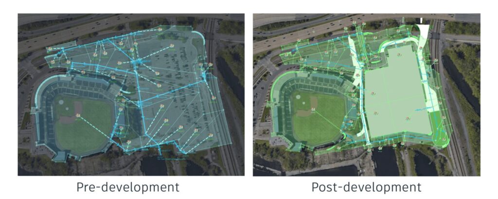
Case study #1: Taking the tides into account for a waterside stadium
One of the most important capabilities VHB was seeking was the ability to simulate extremely accurate tailwater conditions. To test this, they tried the software out on a project alongside the Elizabeth River, modeling the drainage for a sports stadium that occupies a large footprint. But it’s also a shallow footprint, leaving little room for adding drainage design features, which meant they needed to pack as much water volume underground as possible in their designs.
The tidal influence on the area is significant, with high-tail water elevations at the stormwater outfall and low existing ground elevations. The stadium is also in a FEMA flood zone, so the area is historically vulnerable, but forward-thinking engineers know that looking further into the future is becoming essential. They need to be able to model the effects of not just tailwater conditions but also global sea rise.
“This is a situation where dynamic routing comes into play, where you’re balancing rainfall with tide,” says Ewing. “There’s going to be a push back and forth between your precipitation and your tide elevation – they’re going to fight each other. You need a program that’s capable of understanding that push and pull, one that can show you where the flooding is occurring and if there is a backwater condition occurring upstream. InfoDrainage is capable of doing that routing with the SWMM model. Spreadsheets cannot do that. They cannot show you a change in direction in your outputs. Only an advanced model like this can show you that and provide those inverted hydrographs so you can better understand how your system is going to function when you have tidal conditions.”
Because they needed to handle potentially large volumes of water, they took the approach of designing shallow pipes with large diameters for the system. By utilizing high tailwater inputs inside of InfoDrainage, they were able to effectively model and account for forecast sea level rise in the region, using InfoDrainage for dynamic routing on the project and creating a detailed analysis of tidal conditions that balanced rainfall with the tides.
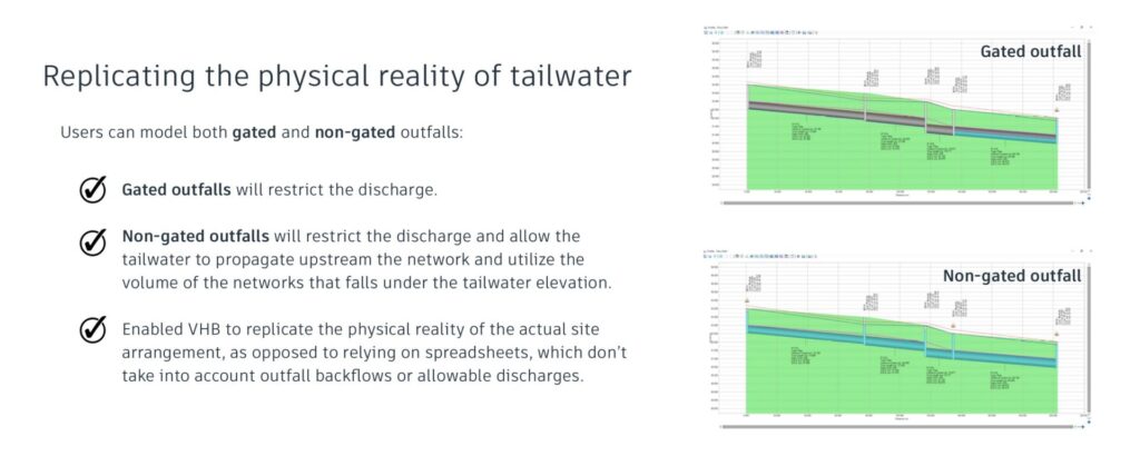
“InfoDrainage uses the dynamic wave formulation of the SWMM engine, which is the most advanced formulation,” says Muhandes. “It’s more advanced than the kinematic wave, allowing for the backflow to happen. It mimics the physical reality of water hitting a restriction downstream, building up, and then flowing upstream.”
“I have seen a lot of spreadsheets that tell you a happy story, showing that a certain arrangement for a drainage network will be discharging water to the river or to the sea. The numbers look amazing at first glance, and the authorities might approve them. But when you put them in dynamic software, it will tell you a different story. It can show you the exact vulnerable point when the system will not be discharging any water because of the downstream condition or because of backflow.”
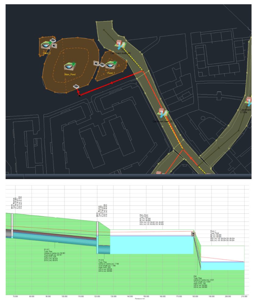
Case study #2: A local university goes green
For an inland project at a nearby university, VHB was tasked with designing a green infrastructure-based drainage system. The site had low existing elevations but also a complex stormwater system, making the need to understand the real-world conditions of the existing network crucial. A lot of off-site drainage passes through the site from upstream.
To meet the volume demands of the site, they designed numerous bioretention beds along with areas of permeable pavement. They were able to develop and model all of these interconnected stormwater controls (SWCs) inside InfoDrainage, including offsite drainage base flows into their model.
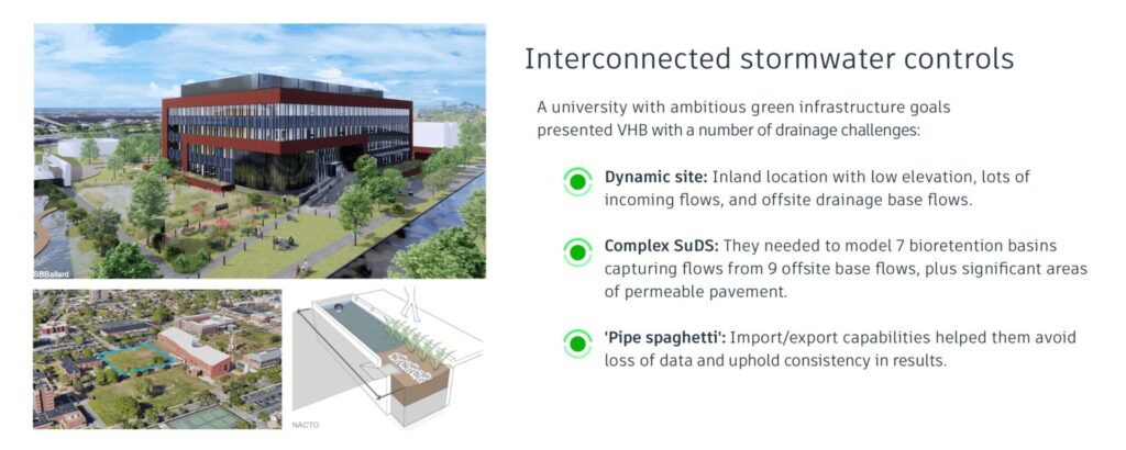
“We have seven bioretention basins surrounded by a permeable pavement footprint around the building and nine off-site base flows traveling through the site,” says Ewing. “That is a fairly complicated setup for your typical modeling software, where you would need at least two different modeling softwares to model something like this, potentially three. InfoDrainage really shines in a design like this.”
“The benefit of using InfoDrainage for this type of design is the interconnected stormwater controls (SWCs), also known as BMPs. Here, you have multiple BMPs connected to each other upstream and downstream, and also incorporating those large pipe systems. We like to call that ‘pipe spaghetti’. When you have a complicated system like this, the import-export benefit of InfoDrainage is your friend. All of that work that you’ve already done in CAD, building your pipe networks and building your catchments, you can pull that information directly into the model, and that saves an astronomical amount of time.”
“The benefit of green infrastructure is not only the fact that we have extra volume to play with,” adds Muhandes. “It has a lot of other benefits like water quality, amenity, and biodiversity. But the most important one is the delay. As engineers, we all try to basically squeeze or squash that peak and hold on to the water so we can delay the runoff or the contribution from a certain area to the public sewer. We’re holding on to the water, and we’re trying to wait until the peak of the storm is gone.”
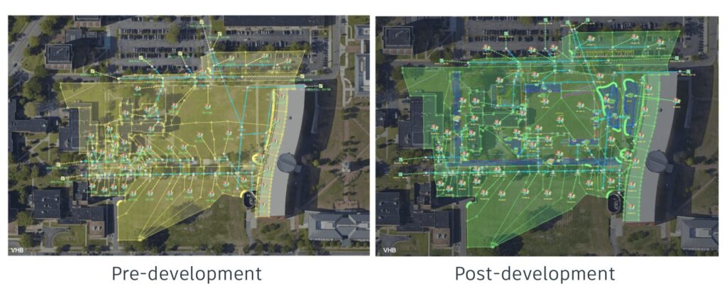
“What’s important to know about InfoDrainage is that it’s not simply displaying nodes and pipes and structures but polygons, and these polygons can very accurately account for time of concentration for water to pass through them. Plus, all of these SuDS are interconnected. They’re talking to each other. They’re all one smart object in InfoDrainage, and you can model all of the interactions. This helps us as engineers understand the role of sustainable designs properly, not just based on the volume introduced into the system, but also as a delay that is introduced to the hydraulics.”
While traditional methods of representing green infrastructure may involve simple linework that incorporates no spatial awareness and dummy inlets, with InfoDrainage the VHB team was able to exactly represent the SuDS structure inside of the model with accurate parameters like roughness coefficients, hydraulic conductivity, and infiltration rates of various layers. At the end of the project, by incorporating green infrastructure into their design, they were able to generate a net runoff reduction for the site, as well as delay the runoff flows, making them more sustainable for the surrounding area.
Case study # 3: Roadway drainage improvements
When a road ages, so does its drainage. When it comes time to refresh or widen the road, drainage engineers sometimes look at how localized flooding has shaped the area to determine if they can preserve a “natural” inflow that has emerged over time. VHB initially took this approach for a city road widening project, simulating a 100-year storm to see when water began ponding.
“We basically tried to expand on those localized flooded areas and improve upon them and create smaller pockets, small ponds, if you will, potentially by retention basins if we can get the volume to work,” says Ewing.

They had a very tight footprint to work with, but they were able to create an initial model with InfoDrainage using small, interconnected ponds that made their way to two separate outfall points, all of which took into account the interconnected conditions. In theory, it met the requirements, but they began to wonder if it was the optimal solution.
“Although we were successful in meeting state regulations and putting in these small ponds along the roadway, InfoDrainage also allowed us to look at the system as a whole and say, ‘Hey, maybe this isn’t the best approach.’ Having small pockets of water next to a roadway means that safety comes into question. Is this the best way to do it? Maybe this needs to be simplified. Maybe we need to look at a regional BMP all the way down where the outfall point is rather than having these small pockets of water.”
“When it comes to interconnected stormwater controls, the game here is to provide the right volume in the right place,” adds Muhandes. “InfoDrainage will allow you to model accurately and replicate the physical reality, telling you, for example, after 300 minutes, it’s going to overflow to the left, and then it’s going to overflow to the right – and then both of your ponds will be utilized.”
“What makes it powerful is that you can easily simulate this in alternate ways, as many as you wish. Maybe it’s a better approach to have a smaller pond and start overflowing earlier. Maybe it’s better to have a bigger pond and not have two overflow arrangements. The options are unlimited when it comes to drainage. You could try 47 different options to solve one problem, if you wanted to, which gives you the confidence to know that you’re adding volume in the right place at the right time.”
Closing thoughts
In the closing thoughts of her AU presentation, Ewing asks the question, “Is InfoDrainage worth it?” She lists three main reasons other drainage designers should consider adopting the software:
- Interoperability: The import/export of pipe systems and catchments saves a tremendous amount of time and preserves accuracy, particularly on very complex systems.
- SWMM5 with benefits: The SWMM engine is recognized in the US as almost a standard for drainage designers. InfoDrainage not only utilizes the SWMM model, but improves upon it.
- Interconnected BMPS: Being able to interconnect and control your BMPs/SuDS and add backwater and tidal effects in one single application is both accurate and efficient.
Go deeper into the story
- Watch the full Autodesk University class, which goes even deeper into these three case studies. You can even download the class presentation and handouts.
- Dig into other popular drainage design classes and talks at AU, which we’ve collected for you on the One Water Blog.
- Try InfoDrainage yourself by downloading a free trial for 30 days (no credit card required).