The City of Brookings in South Dakota, like many other inland US cities, is struggling with increased amounts and instances of flooding. They enlisted ISG, a nationally recognized, 100% employee-owned, multi-disciplinary architecture, engineering, environmental, and planning firm to help them update the city’s master drainage plan, which hadn’t been revised in 15 years. ISG’s Jacob Rischmiller shared his experience working with FEMA at Autodesk University in the presentation Refining FEMA Flood-Risk Maps Using Appropriate Technology: A Case Study of Brookings, South Dakota. We’re excerpting some of the highlights here, but we encourage anyone interested in using InfoWorks ICM in coordination with FEMA to watch the full presentation.
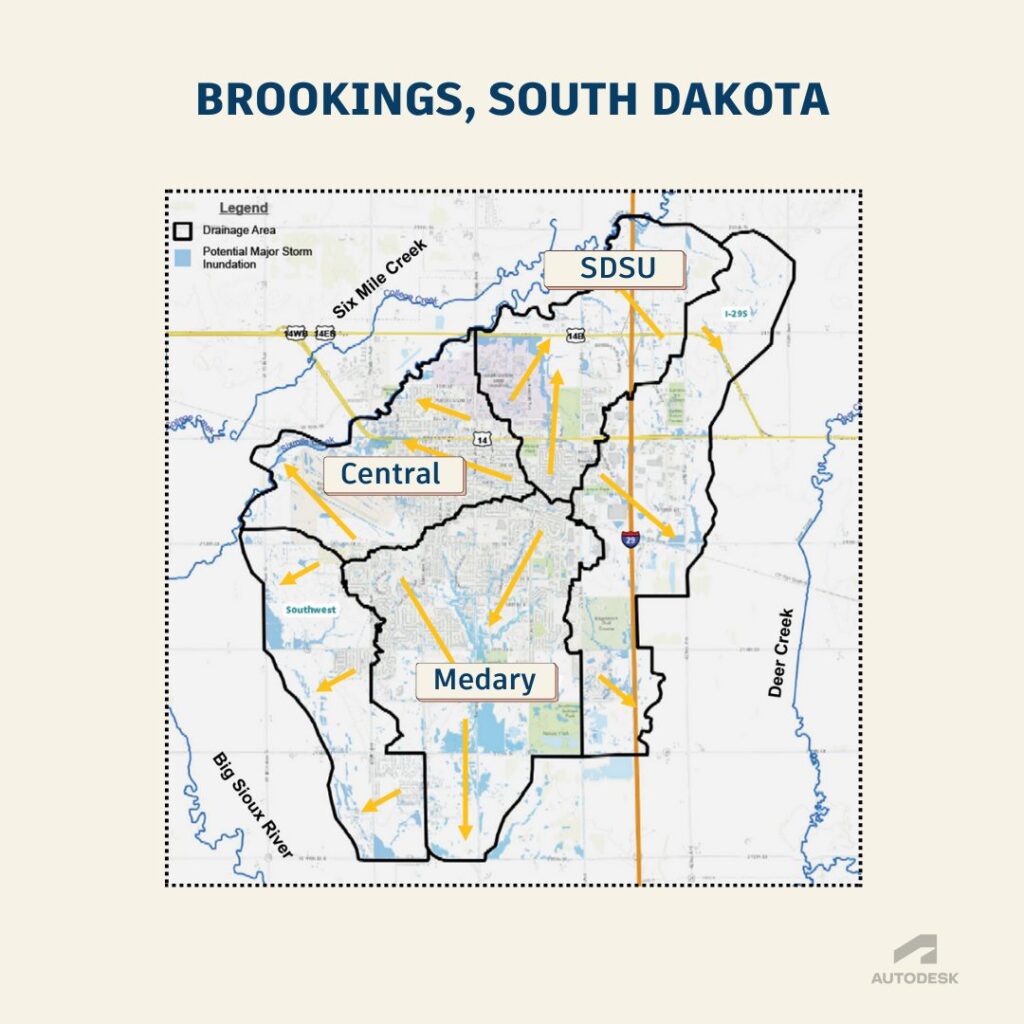
Brookings, South Dakota is located in a tight geographic position, surrounded by two creeks – Six Mile Creek to the northwest and Deer Creek to the east – as well as the Big Sioux River. “Flooding is a critical aspect to understanding the city,” says Jacob Rischmiller, head of ISG’s Water Resources Practice Group. The firm was enlisted by the City of Brookings to help them plan for the future, and that planning – like most planning in the US – begins by consulting official FEMA flood maps.
ISG began by evaluating both historical FEMA flood maps and newly proposed FEMA maps. Their intention was to reconcile the existing flood risk with historical records, add any partially completed evaluation data, and set up meetings to get buy-in from both FEMA and local stakeholders, including the public. But something didn’t seem to match up. The original FEMA maps and the proposed FEMA maps were quite different.
This isn’t uncommon. As useful and helpful as these maps can be, time and technology marches on. A lot has changed since 2008 when the last FEMA flood maps were created for the Brookings area. New data has emerged, along with much more accurate methods for capturing that data like LIDAR surveying. Flood modeling software has also made major strides, giving modelers powerful new ways to use that data to better envision their water systems holistically, not as something static that you print and hang on the wall but as dynamic images and video that can show you – and your stakeholders – exactly where a city will be inundated during a 100-year storm.
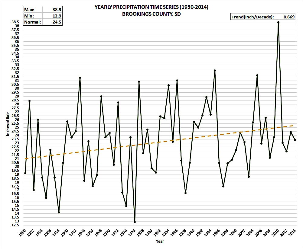
The climate is changing as well, which means warmer weather is bringing more rain, which means that rain needs to somehow be accounted for in our flood models. As outgoing FEMA director Deanne Criswell told CNN, “FEMA’s maps right now are really focused on riverine flooding and coastal flooding. When we’re seeing these record rainfalls that are happening… that’s what our flood maps don’t necessarily take into consideration.”
This is a situation where we, as modelers, can help.
Better data makes for a better map
The City of Brookings initially wanted to evaluate the new FEMA flood risk maps, but as ISG began work on the project, the scope of their work expanded to encompass a completely new Master Drainage Plan to assist in future development and capital improvement projects. With this expansion of the project, ISG wanted to ensure they were using the most accurate tool for the job, so they turned to InfoWorks ICM, a regular tool in their toolkit.
“InfoWorks ICM’s advanced modeling features can enhance a master drainage plan from a traditional, one-dimensional model to a sophisticated two-dimensional model,” says Rischmiller. That’s important not just from a technical standpoint, but from a wider data-sharing perspective. “This modeling gives the community a detailed analysis and deeper understanding of what conditions may look like under a certain flood event.”

As Jacob’s team at ISG began analyzing the existing conditions of the city, they chose to focus on three key areas to accurately assess vulnerabilities and refine planning approaches. For each of the three locations in the city – the university, the Medary area, and the central district – they developed detailed maps to highlight drainage area, inundation zones, and existing stormwater infrastructure.
Using InfoWorks ICM, their stormwater team developed a detailed analysis of impervious areas, sub-watersheds, and land use patterns in the area. They were then able to incorporate critical infrastructure components, including storm sewers and existing buildings, to create a highly accurate representation of the varied landscapes. By integrating this data into the model, they were able to not only simulate current flooding scenarios, but also anticipate potential impacts down the line, giving the City of Brookings a comprehensive tool for informed decision-making and flood management.
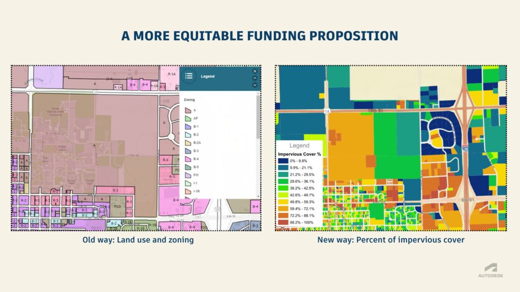
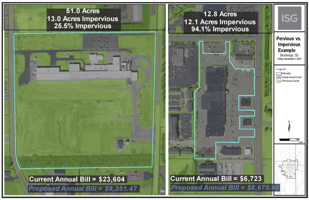
Funding was also a big opportunity. The city had long utilized a common method for funding stormwater improvements that was based on land use and zoning, but they saw the potential for a more equitable funding scheme that taxed properties on the amount of impervious surface on a lot, which of course can dramatically affect rainwater runoff amounts and rates. Should a mall with a giant concrete parking lot pay as as much tax as a grass field of the same size? This is an innovative approach, and one where flood modelers may be uniquely capable of contributing by providing solid data to back up proposals.
Optimizing flood models with InfoWorks ICM
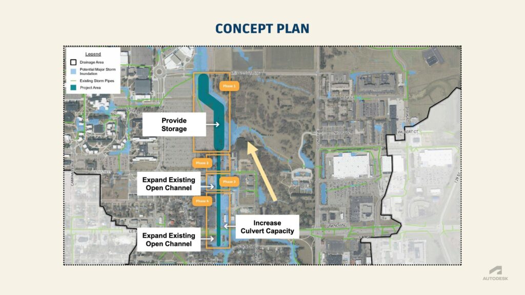
While developing a highly accurate model inside of InfoWorks ICM was one task, the team at ISG needed to help the city identify opportunities for infrastructure improvement throughout their catchment to inform capital planning and land use. For that, they relied on a prioritization matrix that incorporated categories citizen safety, protection of critical infrastructure, protection of habitable structures, location in the basin, and environmental impact, assigning each potential zone with a score.
“First, we focus on providing storage solutions either upstream of – or at – the flooding location to effectively manage excess water. Second, we work on increasing water conveyance within the flooding area to enhance flow capacity and mitigate overflow risks. Finally, we implement additional storage solutions downstream of areas where we’ve increased conveyance, ensuring that any additional flow is managed and preventing downstream flooding.”
The prioritization process, like all of their work, took a data-based approach, but even the most solid data has to be achieve buy-in from stakeholders. That’s where FEMA and local community engagement came into play.
Getting stakeholders on board
As anyone who has worked on a federal flood insurance project before knows, getting FEMA’s approval for your stormwater model is a must. ISG was confident in InfoWork ICM’s simulation ability and accuracy, and it is on a list of hydrological numerical models that meet the minimum requirement of the National Flood Insurance Program, but sometimes it can be unclear if FEMA will accept your tool of choice. Is it too risky for flood modelers to bring a new tool to the table? ISG had compelling reasons to push for more accuracy by using InfoWorks ICM, including the advanced meshing capabilities.
“The original maps were developed based on a one-dimensional steady-state model,” says Rischmiller. “That is really just taking the channel and cross-sections of the creek and the rivers and sending flow down it and developing a flow regime and flood extents from there, versus the updated FEMA maps are actually taking the LiDAR data and topography data that is current as of the modeling that was completed. The city saw those big differences and invested their own money based on their stormwater fees and distribution to develop a full, in-depth, one-dimensional and two-dimensional model for the entire city.”
They leaned into openness and collaboration, engaging the regional FEMA team to partner with them on compliance and planning. ”By engaging FEMA and communities early in the planning process, stronger partnerships that ensure proactive responses to climate change are built,” says Jacob. “This approach fosters open communication, enabling us to address uncertainties and develop resilient strategies that reflect the needs of all stakeholders.”
Cooperation makes it happen
In the end, getting FEMA approval for the InfoWorks ICM models they developed for the project was relatively straightforward. All they had to do was walk the team from FEMA through the workflows and methodologies they used in creating the flood maps, and the new stormwater maps were approved.
Getting FEMA on board with the new flood maps was one thing but given that their update drainage plan and maps would impact land use assessments and insurance, they needed to get the community on board, too. ISG hosted three community town halls to gather community feedback on the new flood maps, inviting city officials, representatives from local utilities, and community leaders to collaborate.
One thing that really helps when you open the doors to the community? Visuals. With the help of the highly engaging visual outputs from InfoWorks ICM, they were able to demonstrate to non-technical stakeholders what would happen under various present and future states. ISG was also able to show that they could output the necessary reporting from the platform to satisfy local approving authorities. Showing – not just telling – how you will make local officials’ jobs easier is always a smart strategy.
“As engineers, we need to know the numbers and the data behind it, but that data only goes so far,” explains Rischmiller. “These visuals really enhance our capabilities and show how powerful our modeling softwares are. These modeling videos have been a huge aspect of the work we do at ISG to get residents to visually see it.”
Go deeper into the waters
- Watch the full presentation from Autodesk University and download the accompanying presentation and handout.
- Other cities have used InfoWorks ICM for massive flood modeling. Read our customer story about The City of Fayetteville’s flood resiliency in the face of climate change: mapping 15 watersheds.
- If you’ve never used this software before, you might be wondering: Does InfoWorks ICM use the SWMM engine? Yes! Here’s everything else you need to know.