CSD ENGINEERS
Collaborating in the cloud is more efficient for complex infrastructure projects
How combining BIM and GIS data in a common data environment
improves teamwork
Brief summary of key points
As a company specializing in the design of complex environmental and infrastructure projects, CSD Engineers works with extensive data sets on a variety of platforms. Using the Autodesk Construction Cloud (ACC) and the ArcGIS GeoBIM extension, CSD brought together a range of disciplines, workflows, and terminology from the worlds of BIM and GIS (geographic information systems). The project they chose for piloting this approach placed equally demanding requirements on BIM design data and on geodata.
BIM program director David Teillet and GIS analyst Léo Ficheux led the pilot project together. Here they explain the approach they took, the challenges they encountered, and the lessons the company learned for its internal processes as well as for future projects with other customers.
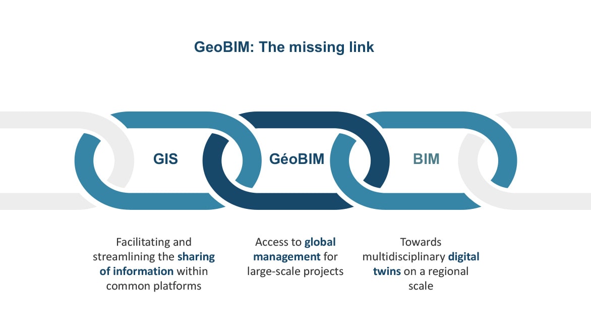
GeoBIM: The missing link.
GeoBIM: Bringing together two different worlds
As its projects grew increasingly complex, CSD responded with the ACC and GeoBIM. Collaboration between BIM managers and environmental engineers, coupled with rising ecological and regulatory pressure, required that they employ the GeoBIM extension to combine their BIM and GIS data in the ACC.
BIM and GIS are two completely different methods, each with its own data, terminology, and processes. Combining them, however, increases project understanding enormously. This in turn enables thoroughly informed preliminary planning, avoids expensive errors, and increases efficiency over the project lifecycle.
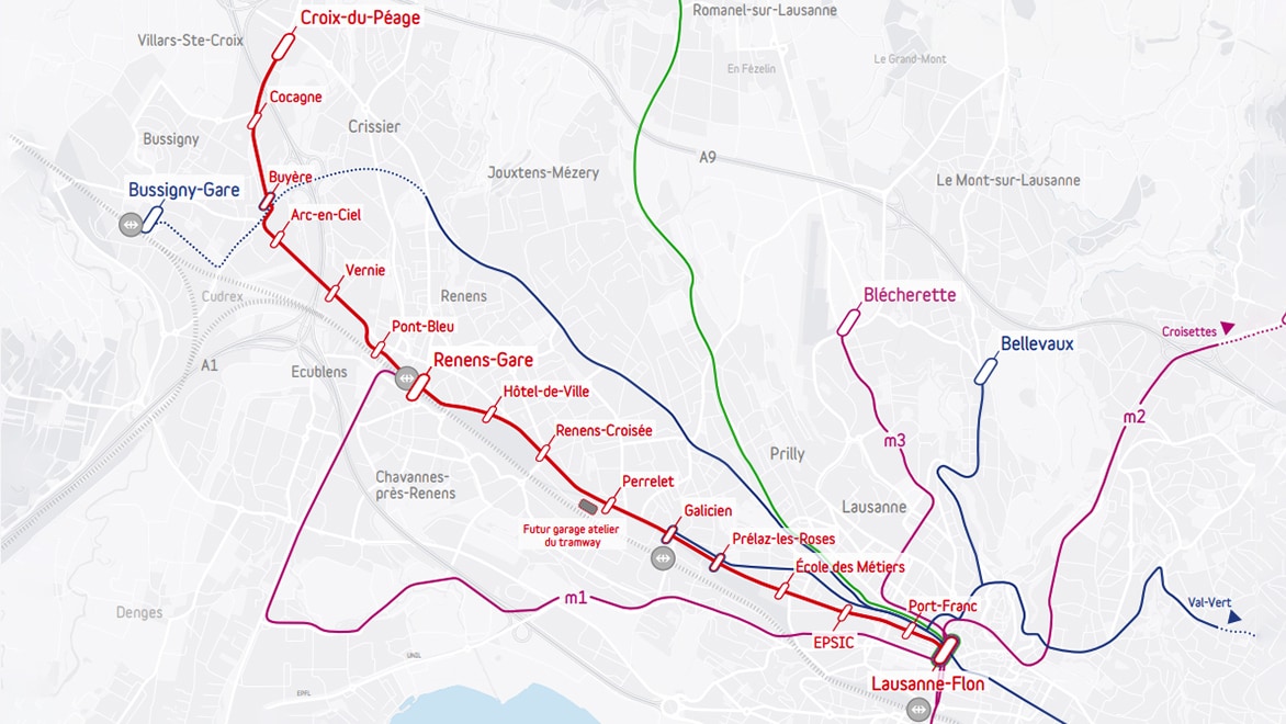
The new trame line between Lausanne and Villars-Ste-Croix – with a length of 7.7 kilometers, it will serve 15 million passengers per year.
The pilot project: A new tram line between Lausanne and Villars-Ste-Croix
As the BIM program director at CSD, David Teillet is part of the company’s digitalization team. This team brings together industry specialists and IT experts to find the most effective digital solutions for CSD’s engineers and then implement them. It was this group that gave the initial push to introduce GeoBIM.
The first step was to take stock of the status quo: What are the various BIM and GIS teams working on? What requirements do they have regarding the available data and the value they can add to overall project planning?
To answer these questions, David spoke with his colleague, GIS analyst Léo Ficheux, and together they hashed out the criteria for the project and its team from both their perspectives.
The two engineers identified the infrastructure project for building a new tram line between Lausanne and Villars-Ste-Croix, Switzerland, as a perfectly suitable pilot project.
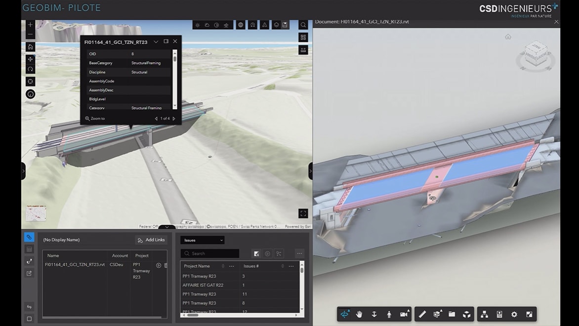
View of the bridge over the A1 in GeoBIM – the most complex structure in sub-project PP1.
Dividing the mammoth project into sub-projects
The mammoth project—which called for 16 new stops along 7.7 kilometers of tram track, carrying 19 million passengers annually by 2030—was initially broken down into multiple subprojects. Some of them were localized, such as pure BIM and construction projects, while others were distributed across the entire undertaking; for instance, environmental impact analysis or mobility studies. One of these subprojects was PP1, which included the entire route between Renens station and Villars-Ste-Croix, Croix-du-Péage, with the tram bridge across the A1 being its most complex structure.
“As part of this subproject, we spoke with various people involved and quickly realized that several other infrastructure and construction projects depended on it,” David explains. As the first subproject, PP1, was still in the planning phase, CSD decided to start merging the BIM and GIS approaches there.
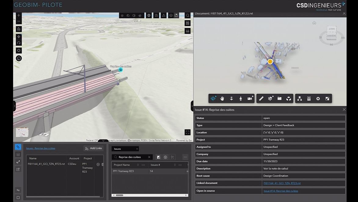
Problem on the bridge abutment in the GeoBIM view.
Merging isolated workflows and data sets
The first challenge quickly emerged: the GIS and BIM teams work using different software and cloud systems and diverse terminology. The subprojects were at different stages of implementation, and both areas were working with varying formats, platforms, and underlying reports and studies.
Léo and David explain what this all means for day-to-day work by referring to the way each group makes comments: the BIM-based system makes it possible to incorporate problems into the planning process in the form of objects called “issues,” which could be translated in the GIS world as georeferenced points with dedicated attributes. In other words, two different methods, each inherent to its respective world, but producing one result in the GeoBIM solution.
By adding the ArcGIS GeoBIM extension to the ACC, CSD was able to merge these two worlds on a single platform: BIM optimizes GIS environmental data with detailed object models that may serve to improve operations and maintenance, while GIS maps an object’s actual contextual data. This makes real data on the conditions of the construction project immediately clear, meaning that not only can all teams recognize potential conflicts more quickly, but they can also resolve them faster on a firmer data footing.
“Thanks to GeoBIM, we can pool GIS and BIM data across platforms.”
David Teillet, CSD Engineers
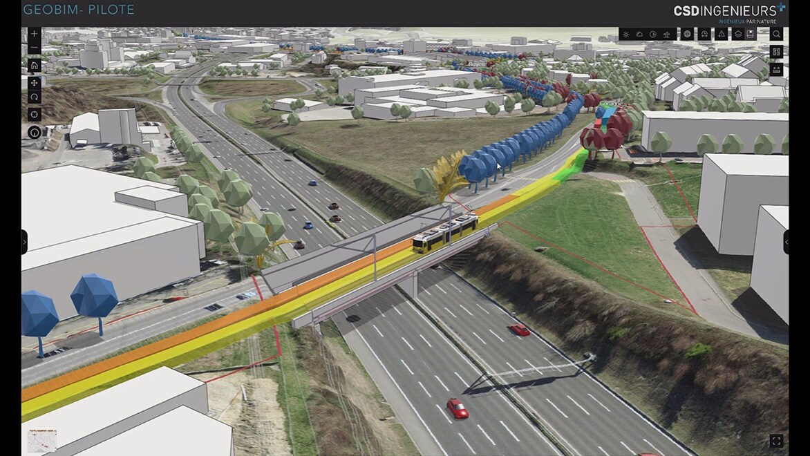
Images of the construction site in Arcgis/GeoBIM.
Successful integration of new working methods
Following the success of the pilot project, CSD gradually integrated further parts of the Lausanne – Villars-Ste-Croix tram project into the new workflow—with the potential for opening up the project to its customers. Now it’s not only the CSD engineers who can communicate together but other teams as well. And thanks to the expanded visualization and evaluation options offered by ArcGIS GeoBIM with Autodesk BIM Collaborate Pro, it’s possible to combine precise terrain models, building plans, and environmental analyses online.
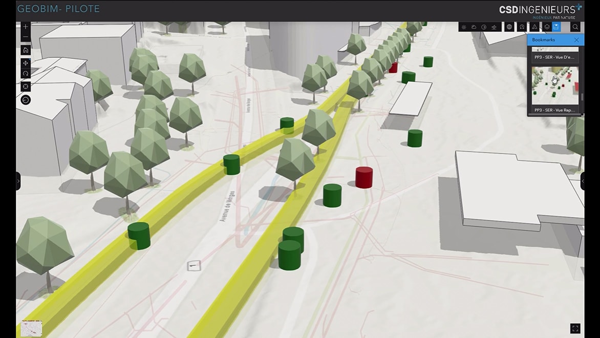
Bridge with map, illustration of streetcar speed limits and trees added or removed for this or a future project.
More efficient decision-making
All project stakeholders can reach sound decisions together, to the benefit of all subprojects. For example, knowledge about environmental regulations or how to handle certain terrain situations can be used in other parts of the planning, without spending a lot of time and money going over the same ground.
“Especially for infrastructure projects, like the one in Lausanne, there are lots of restrictions due to environmental data or legal provisions—say, with regard to protected species or impact on the neighborhood,” Léo says. It’s now possible to take these aspects into account much earlier on.
Benefits of working with GeoBIM
Thanks to direct data access and the connection of the ACC to the Esri ArcGIS platform, CSD was able to break down data silos and merge disparate data formats:
- Each subproject’s progress is now visible to all disciplines on a uniform platform.
- Differing terminology has been standardized and based on a common data environment to be understandable for everyone.
- BIM managers and GIS analysts alike can access a shared system to keep track of the planning, make comments, and raise points for discussion.
Lessons learned and benefits for future projects
Based on its pilot project with the tram line in the west part of Lausanne, CSD is now in a position to complete new projects of this type faster and more easily. “If we were to start a new BIM-GIS project tomorrow, our current setup would cover 70 percent of the initial steps, since we designed the project structure to be customer-agnostic,” Léo says.
David continues: “Our new way of working is a great help primarily on complex, large-scale infrastructure projects, such as rail lines or ports, but in the future, the planning and operation of smart cities could benefit as well.” The combination of BIM and GIS data can serve as the preliminary version of a digital twin, with which entire cities can be mapped and run.

All images courtesy of © CSD Engineers.
About the company: CSD Engineers
Established in 1970, and now with more than 30 locations in Switzerland, Belgium, Luxembourg, Germany, Italy, and Lithuania, the CSD Group is a leading provider of solutions for the energy, environment, rail, and road infrastructure industries, as well as for waste management and the circular economy. The engineering experts at CSD handle a wide range of tasks: they monitor the environmental impact of complex infrastructure projects such as the Gotthard base tunnel, issue reports on contamination, draw up remediation plans for large industrial sites, and plan environmentally sound renovations, extensions, and demolitions in the raw materials and energy industries. One highlight project was the construction of the School of Life Sciences at EPFL (École polytechnique fédérale de Lausanne) in Switzerland.
Autodesk Solutions
-
Powerful BIM and CAD tools for designers, engineers, and contractors, including Revit, AutoCAD, Civil 3D, Autodesk Forma, and more
-
Cloud-based design collaboration and coordination software for architecture, engineering, and construction teams to review designs, run automatic clash detection, and track project status.
-
Cloud-based design co-authoring, collaboration, and coordination software for architecture, engineering, and construction teams. “Pro” enables anytime, anywhere collaboration in Revit, Civil 3D, and AutoCAD Plant 3D.


