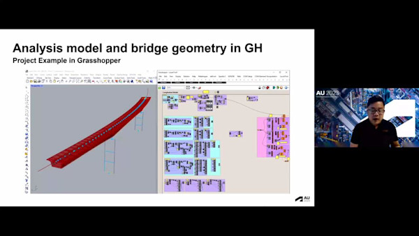
AU Class
AU Class
class - AU

BIM and GIS Cloud Collaboration Panel: Actionable, Connected Data Environments

Share this class

Description

Recent global impacts are changing the way infrastructure is planned, engineered, constructed, and maintained. More process participants are working remotely, teams are progressively distributed across locations, and requirements for collaborative cloud environments have dramatically increased. This has all coincided with streamlining connections between building information modeling (BIM) and geographic information system (GIS) workflows and sharing new system engagement views with more collaborators in ArcGIS GeoBIM. Although customers are benefitting from cloud-to-cloud integrations, others wonder how best to modernize their approaches in order to reduce risk, increase transparency in infrastructure asset delivery, and bridge information gaps between project participants. Come learn how teams from Arcadis, HDR, HNTB, and VolkerWessels are connecting their BIM and GIS data environments that inform stakeholders on progress, easily sharing process views of complex projects and planning sustainable business practices for teams, clients, and the asset lifecycle.

Key Learnings

  • Learn how teams are addressing infrastructure workflow roadblocks today with new ways of working.
  • Learn about planning strategies that will change business outcomes throughout delivery and into operations.
  • Learn about cloud technology efficiencies in BIM and GIS that streamline collaboration and access to data.
  • Learn about using new solutions and methods to drive risk awareness and stakeholder engagement.

Speakers

  • Clay Starr
    As Esri's Architecture, Urban Planning & Design Lead, I am responsible for setting the overall strategy on how GIS enables designers and planners to radically improve their response to the challenges they face, deliver data-driven results, and generate new and better outcomes through the geographic approach. The digitalization of our industry over the last 2 decades through the data-rich BIM process has laid the foundation for this next evolution in design and it's an exciting time to be part of the AEC!
  • Avatar for Francois Appere
    Francois Appere
    François Appéré acts as Sr. Manager of the Global Autodesk Platform Team at Arcadis. He serves as the key point of contact between Arcadis and Autodesk and supervises the Autodesk contract management, ensuring the Arcadis workforce accesses the best of the Autodesk technology. François has a strong background in civil engineering, construction, BIM process, change management, and leadership. Over the past 6 years, he was responsible for implementing BIM within the Arcadis France and North American businesses, following the Arcadis corporate initiative to 100% BIM. François is an active and long-time member of the Arcadis digital engineering community, setting up the digital future and vision of the company. He is passionate about improving design and construction processes as well as leveraging new technologies to reduce our overall impact on the natural environment.
  • Darin Welch
    As a leader in HNTB’s Technology Solutions Center, Darin leads a team of talented support staff for many of HNTB’s most significant GIS consulting and asset management projects. He brings a substantial level of knowledge and thought leadership through his strong technical background in geospatial systems integration, technology project management, enterprise GIS implementation, and application solutions development. For more than 21 years at HNTB, Darin has been refining his skills in the geospatial arena with a focus on leveraging existing software investments, configuration over customization, systems integration, and emphasizing the importance of the end-user experience. While his early career focused more on GIS support for civil design services, he has used that foundation to build with his team a portfolio of modern geospatial solutions for rail/transit, aviation, bridges, and roadways/tolling.
  • Cameron Schaefer
    As an experienced design technology leader and innovator, Cameron currently serves as the BIM Lead for the LAX Automated People Mover (APM) Project. Cameron’s responsibilities include the oversight and management of all 3D model deliverables across the entire design scope of the projects 150+ design models, 300+ designers and more than 15 design firms. Being HDR’s largest BIM project and one of the largest BIM projects in the nation, Cameron is in charge of ensuring models from civil utilities through station structural meet contractual LOD requirements for use in 4D Phasing, 5D Estimating, As-built and O&M use cases. Cameron has extensive experience specializing in blending horizontal (Civil) and vertical (Architectural) projects across multiple platforms to ensure project teams are communicating as efficient as possible with minimal data loss between cross platform applications.
  • Avatar for Jeroen Tishauser
    Jeroen Tishauser
    Meet Jeroen, a seasoned specialist in information management at VolkerWessels Infrastructure. With an impressive two-decade career in the realm of large-scale road and rail construction projects, Jeroen is more than just an industry expert—he's a driving force of innovation. Throughout his journey, Jeroen has harnessed his expertise in Autodesk, Trimble, and Bentley products to optimize project workflows. His unique blend of engineering prowess and programming skills has not only shaped best practices but also paved the way for smoother information flow in projects. Jeroen's dedication to progress extends beyond his daily work. He's a trailblazer and a founding member of the Autodesk Civil Infra Benelux User Group and the Association for Infrastructure Design in the Benelux. Currently, he wears multiple hats, serving as an information manager for diverse projects in both bidding and construction phases. Additionally, he holds the role of product owner for Digital Twin within the Digital Innovation stream, where he continues to push the boundaries of what's possible in the industry.
Video Player is loading.
Current Time 0:00
Duration 1:01:50
Loaded: 0.27%
Stream Type LIVE
Remaining Time 1:01:50
 
1x
  • Chapters
  • descriptions off, selected
  • en (Main), selected
Transcript

CLAY STARR: Hey, thanks for coming out, the last day of AU. I don't know what your weeks have looked like, your days and nights. I've tried to take it really, really easy, these last few days, now preparing for this. So thank you for coming.

Today's session is going to be real informal. While it is a panel discussion, and we've got some questions prepared, we really want to hear from you guys. We've got our lovely assistant down here in the front, the handheld mic. We'll open up for questions, and just kind of have a dialogue. But we'll kind of get kicked off.

Today, we're going to be talking about BIM and GIS cloud collaboration, right? The focus of a lot of the attention this year at AU has been around how do we collaborate across disciplines, how do we get more people involved, and more stakeholder engagement. So I've invited to our panel today, Darren Welch from HNTB, Jeroen Tishauser from Volkerwessels, Cameron Schaefer from HDR, and Francois Appere from Arcadis.

And I'll give them an opportunity to introduce themselves here in a moment. So continuing on, there's not a lot of slides. We may have some examples, as needed. But really it's designed to be an introduction. So a little bit about me, I work for Esri. I'm part of our global accounts team. I've been in the BIM world for most of my career. It started-- oh sorry, I thought that was-- we're competing. I thought I had a video playing.

So I've been in the BIM world for a long time. I think I calculated, is part of my 16th Autodesk University, a lot of great conversations, a lot of the same conversations. But they've evolved really well over the years. My specialty within the accounts team is to grow our customers, and make sure they are successful. I asked all of the guys to prepare like a little fun note about them. So my fun note is I actually play five musical instruments. I'm a musician. I'm not a professional at any of them. But it is something I do enjoy to do.

So these guys will get a chance to introduce themselves in a moment. But I want to set the stage. Like, why are we here? Why did we come to Autodesk University? Why do we go to conferences and talk to each other about what it is we do? Yes, it's fun to learn about new tech. Yes, just it's fun to learn about roadmaps and understanding where the industry is going.

I like to talk about productivity. I like to get to the why, the root cause of why it matters that our technologies work together, and why we're teaching people how to use them better. Some stats that have been thrown around for a while now that I've kind of latched onto, is really around productivity, specifically around waste. At the moment, in the AEC industry, 30% of all materials that wind up on site, they wind up in a landfill.

And there are a myriad of reasons. We've all heard why that happens. But that's a significant number. 30% of our projects are over budget. Now again, there's reasons why that might exist. Perhaps the budgeting process is archaic or broken, or maybe we're just bad at our jobs, right? And there's a spectrum of that. There's lots of reasons as to why-- communication breakdown, data transfers, et cetera. But we do find ourselves in a situation where we are not only over budget, but 40% of the work we're doing is rework.

These are errors, omissions, things that sort of pop up in our day-to-day lives. And we all find ourselves trying to make better, right, through our technology, hoping that sometimes our tools will mitigate some of those risks. But the truth is 90% of our projects are late as well. So when it comes to defining what it means for a BIM process and/or a GIS process, or a holistic design process to improve we have to make sure we're addressing these issues.

To put it bluntly, for every three buildings we build, we throw an entire one away. That's how much waste that's being generated. So when we talk about BIM and GIS integration, we talk about the design process, and improving it. These are the goals we're trying to achieve. Yes, we want to be profitable. Yes, we want to reinvest our time into other things, perhaps, rather than just all the rework and re-budgeting of our projects.

But I want to start with the why. So I've been at the Esri booth for the last couple of days. And I've fielded some interesting questions around the feasibility and just ultimately what is GIS. So real, real high level overview, some of you guys may be, some not. But we like to look at GIS through the lens of three very specific channels.

One is GIS is a system of insight, right? We get in early. There are feasibility studies. We're talking business analysis, spatial analysis, these sorts of things that help us determine whether this project is feasible. We talk about a system of record where things like our imagery that we're collecting, or site information gets collected, and maybe it's shared amongst the team to make sure that we're making the right decisions. And we can always go back to this common data environment that says, OK, where is the thing that I need and when is it important?

And then lastly we talk about GIS as a system of engagement. You can see along the spectrum trying to align a lot of our project timelines against that, and the system of engagement is, how am I engaging my stakeholders. How is it changing the role of the design professional or the field professional? How are they influencing or otherwise consuming the information that has been created? How is it being maintained beyond occupancy or beyond handoff?

We could talk more about GIS specifically later. But I do want to get to the value propositions. I'm going to skip right through these. On the left, is what we're all sort of experiencing in the industry, right? We're all talking digital transformation. But what does that really mean to the industry? I think what it means in my 20-plus years in industry is we're trying to digitize our domain knowledge. We're trying to find ways to automate and expedite decision making processes.

Those processes we're creating are often bespoke, right? They're often one-offs. They sit in silos, maybe inside of our organization. When we're really looking to scale solutions, we're trying to find ways to get these productivity gains outside of our little team. We lean on custom development. Maybe it's full stack. Maybe it's little apps here and there. But you know we're looking as an industry for out-of-the-box solutions. Like what can we do now?

No, there's no magic button. No, there's no digital twin button that's going to ever appear in anybody's software ever. But we're looking for these managed opportunities for us to just get our work done. And lastly, we have this disparate technology that we're desperately trying to aggregate. And we come up with really creative ways to do that. And we lean on our vendors. We lean on our technology leaders to help us do that.

But what we're really looking for is innovation that is based on data, and that data that we're pulling together helps us make decisions, helps drive the actions. So our guys here on stage that I've invited are all representing some of the best work that's being done in the industry around BIM and GIS, and just overall design development of their process, trying to overcome the things on the left and really pushing toward the columns on the right.

So with that, this is not about me. I invited a panel. I'm not a panel. I'm a person. So with that, these guys are mic'ed up. They're ready for your questions. But I do want to give them an opportunity to introduce themselves. So I'll first hand it off to Cameron Schaefer. You're the first one on my list, so--

CAMERON SCHAEFER: Awesome, thank you.

CLAY STARR: --introduce yourself.

CAMERON SCHAEFER: Thank you. So glad to be here. I'm Cameron Schaefer. I'm with HDR. I'm out of Southern California, in Irvine. I'm our transportation data acquisition director. So in that role, I oversee our reality capture program and digital delivery, how we can better integrate technology into the work that we do.

When we look at HDR, we are an architecture, engineering, environmental, and construction services firm. 11,000 employees worldwide, 200 offices around the globe, 14 different countries that we work in, with 16 different key markets, everything from transportation, water, resources, and so on.

Fun fact about me is I only play one instrument, with the guitar unfortunately. But I'm a self prescribed tech nerd. So I get to do that for my job, and I love it.

CLAY STARR: Nice. All right, thanks. Yeah, one instrument is not as cool as five, but that's great. Oh, Jeroen, please. You're up.

JEROEN TISHAUSER: Hi, everyone. My name is Jeroen Tishauser. I work for Volkerwessels, which is a general contractor in Holland. My background is in civil engineering. I'm a road designer by trade, most of the bigger infrastructure projects. Background in IT consulting, and support, training, giving training to people. And currently my role is information management. So I'm taking care of the business, getting information from the site, putting it out to the client, and handover, and commissioning states.

Fun fact about me, I do martial arts, and brown band in both of the jujitsu and judo. So hopefully, I'm getting my way around New Orleans. Anyway, and photography is a key point in my career. Volkerwessels is known by one brand, not only one brand. We have different markets. It's also based in the US, although small, Canada in major maintenance contracts.

We have 25,000 projects a year, big companies, and some interesting numbers if you are a financial director. But anyway, I'm from Holland, from infrastructure department and we also have a building department coming up. So, thanks.

CLAY STARR: If you're coming to the AU party tonight there will be a corner in which you Jeroen will demonstrate some martial arts, self-defense techniques for us. Francois?

FRANCOIS APPERE: Hi, everyone. My name is Francois Appere. I'm the Autodesk contract manager for Arcadis globally. I joined Arcadis a bit more than 10 years ago, and I started as a bridge designer. So I come from the business, from the design side. I led the BIM implementation for Arcadis France for a bit more than three years before moving to the US, and lead the BIM push for Arcadis North America for again three to four years, and leading the contract we have with Autodesk globally nowadays.

So a lot of involved into change management, into people management when it comes to technology and digital. My passion, fun fact, I love being in nature, and exploring different ways of moving in nature. And the last two years I've been learning how to fly a paraglider. So if you want to know more about that, reach out.

Arcadis, I've got a few slides about the company, for those who do not know us. So we are-- actually those numbers need to be updated, because we just acquired the IBI Group. That was announced two days ago. So we are now more than 30,000 people around the world, working in a design engineering and consultancy field for natural and built assets.

We have a global footprint, and we recently updated our strategy, which is based on the megatrends that you have seen many times I think during over the past two days-- urbanization, climate change, digitalization, and social expectations-- which have led us to reorganize ourselves around three main business areas which are resiliency, places, and mobility. And the digital solutions are really a way for us to innovate and come up with better outcomes for our clients in those three business areas. So that's it.

CLAY STARR: Yeah. Thank you. Don't talk to Francois about hiking. He doesn't hike. I think you sprint mountains now. You're just running.

FRANCOIS APPERE: I run, yeah. I don't hike.

CLAY STARR: Yeah, that's good. Yeah, that's amazing. Thank you. All right, Darin, thank you.

DARIN WELCH: Great. Good to see everyone today. I am Darin Welch with HNTB. HNTB is a US-based transportation firm. We are about 5,000, 5,500 employees now, I think, about 70 offices nationwide. And we specifically focus on transportation, so DOTs, transit agencies, airports. And that's where a lot of our bread and butter is.

The group I'm in within HTNB is strictly focused on digital innovation services. So we're not a skunkworks group. We actually provide digital innovation as a profit center, partnering with our offices around the country that are serving our clients more directly. So out of the 70 or so digital innovators in the group I'm in, I oversee about 25 of those who are focused on geospatial community and design innovation.

And that's where really a focus of our discussion I think today will be is, how are we taking elements that have been really strong in GIS, especially in planning and community engagement traditionally, and how do we blend that in a really valuable way with a lot of the design, both horizontal and vertical that we're seeing.

Some fun facts about me, I also play guitar and sing, so we've got the makings of a band here. I've also-- my wife and family and I have gotten really into small-scale farming in recent years, trying to be a little more self resilient. So I have about 100 baby chicks at home right now that my family's taking care of. And because I also love technology, they've got it under control, but I'm still checking the live chick cam quite often while I'm here, just to make sure everything's OK.

CLAY STARR: Thanks, Darin. I thought you were going to say that you've chipped all your chickens, and they're all on some tracking device. Maybe that's--

DARIN WELCH: That's the next step of evolution.

CLAY STARR: That's the next step, yeah. OK, now let's get to the meat of the discussion, right? This is now about asking these guys-- I've got a couple of questions started. But like I said, if you have questions that you want answered, and you don't feel like we're getting to it please, please interrupt. Raise your hand. Jeff here will bring you a microphone.

So I'm going to start. And I'm going to start with Darin, because you did bring up specifically stakeholder management. And I want to just talk really broadly, and I'll give you guys all the chance to answer this question. But how has the integration, have you seen that change the way you engage with stakeholders, when you do integrate your GIS and your BIM worlds?

DARIN WELCH: Yeah, I'm going to I'm going to break stakeholders kind of into two categories as well, because we've got stakeholders that are more our project team, and our clients that we serve. And then public-facing stakeholders, the general public, or advisory groups, or regional partners that may be aiding our clients.

So the project team, I really feel like the combination or integration of GIS and BIM have specifically allowed the breaking down of silos. We like to use that term, because everybody likes to stay within their own kingdoms at times. But opening up the ability for especially Autodesk and Esri's technologies and platforms to integrate, especially in a web-based setting, has allowed our teams at all levels, all the way from down in the weeds doers, designers even, all the way up to project leadership.

They can now access and get answers. They can ask questions of the data, especially in 3D, with tools like GeoBIM that's available from Esri now. They can see that at all levels. And really where we're trying to head with this type of engagement is integration without translation that we have on the slide here. So that is a really foundational concept that is important to us as our GIS and BIM integration strategy.

Autodesk and Esri have done a really fantastic job of being able to, no matter what platform you're working in, in terms of authoritative data management, whether it's in ACC, BIM 360, or whether it's in ArcGIS Enterprise, or ArcGIS online-- you can integrate, directly connect across multiple platforms, especially on the desktop. And now what we're seeing with GeoBIM, which I think is approaching about a year old now, still a baby, but what we're seeing is now on the web, that's allowing us to expand to anyone on the project team with ease of entry.

You don't have to know Civil 3D. You don't have to know ArcGIS Pro. You can be a casual user, which a lot of our project leadership is, right? They just need to quickly open an app, ask some questions, maybe do some filters, visualize it and get the answers they need, whether that's about construction phasing or design conflicts that may be underground. Let's shift that though to then public-facing stakeholders.

And I think our or planning twin is an area where I can kind of touch on that. So this is a conceptual example of where we are trying to take the concept of digital twins, which by the way I would argue that digital twin is not a deliverable, right? It's a strategy. It's an approach. So what we're trying to do is say, where are you at in your project with a digital twin strategy, and what's important as a part of that strategy with what you need to share to your stakeholders.

So this is an example of these integrated elements, some data coming from Autodesk Construction Cloud, some data coming from our enterprise GIS, whether it's environmental layers, or as we're showing here feedback from stakeholders on the project. We can bring all of those elements together. And in this case, we're actually sharing in an immersive 3D way through an Esri story map, hey, here is what we're evaluating on the project. We want to be open and transparent with you, the general public. We want to share these design ideas, maybe alternatives, and we want your feedback to progress those alternatives forward through the rest of our design project.

So I think the integration of these areas have really open up and expanded, and really streamlined decision making through our project teams at all levels and to the public in general.

CLAY STARR: Thank you, Darin. Francois, do you [INAUDIBLE]?

FRANCOIS APPERE: Sure. I mean I 100% agree with what's presented here by Darin. And when we speak with the teams, they already tell us that being able to combine that design data we generate in a BIM environment together with GIS really improves the storytelling of our projects. And yeah, we can use that video. Maybe you have to click on play, to run it.

But in fact, that's interesting how in the BIM environment you're all talking about federated models where we combine a lot of different data sources. But it's still hard for non-technical users to access this federated model, because you need a specific desktop tool, or it has been a switch to the cloud of course. But the cloud solutions that we see purely in the BIM environment sometimes are not super user friendly.

And what we find here with combining that with GIS is that you can use, in fact, a cloud based GIS environment to replace that need for a federated model. And here, the example is the remediation of a long stretch of river we are doing in North America. And you see here that that bridge has been loaded in Revit. And you actually access the data, which is in Revit. So it's not just a 3D model. That's a building information model, and that's using that GIS environment was a way for us to provide and give the people who are in charge and who want to take decisions the data they need.

And so that's really the primary use case for us when it comes to BIM GIS connectivity. It's to be able to provide, again, the non-technical people access to technical data, and the right tool to federate point clouds, BIM models, CAD information, federated in one place.

CLAY STARR: Cameron, what about HDR's engagement? Have you seen an increase of the kind of management you're doing with your stakeholders?

CAMERON SCHAEFER: Yeah, no absolutely. And I think one of the things on our end, and I completely agreed with everything just said. But where I think this really helps is stakeholder engagement, similar to what Darin was saying, with our own internal team, and then our external partners or clients.

The simple beauty of it is we have all of this information. We've had information for a long time. That hasn't been the problem coming up with more information. It's been how do we use that information. And how do we store that information? How do we make it available?

And so prior to us integrating our BIM world with the GIS world, getting that information to the project managers, to the client, to the public was a function of us doing that work ourselves, us coming up with the $5,000 laptop, having the horsepower and the hard drive capacity to show all of this information together, and cut the sections and know how to use these tools. Which is great, right? We have the information. We can do that.

But just a couple of slides here showing one of our examples, and I think there's a couple of videos that I'll play as well. What we now have the ability to do is on one project bring in well over 500 models that live on BIM 360 or ACC, which are the actual design models. These are the design models that we're progressing. That's accurate information, and we're able to bring that into an environment that is now accessible and easy to use.

And I think that's a very simple statement, but it's very powerful. Right? Because this information that is so valuable is being used by people who didn't previously use it, who weren't previously able to use it. And what that does is that enables the digital transformation that we all want right. That helps that to progress. That gets people involved. It gets people asking questions.

And then I think the second key thing about it is data accuracy. Right? It's one thing to throw models up on a hub, and information up on a hub. But if you start showing outdated information, you're almost going backwards now. Right? You're losing trust in the tool. And that's where some of the integrations that have been coming out, being able to update these models on a real time basis, are incredibly powerful. Because if that information can be trusted, then it's used even to that next level.

And then the last thing is a simple example. We're seeing some examples of point clouds and reality mesh information, right? This one project here, we've got 10 terabytes of point cloud information. 5, 10 years ago, you're never going to have a project manager who's looking through 10 terabytes of information. But you can do that now, right? And that's a very powerful tool.

CLAY STARR: So Jeroen, I want to ask you maybe a follow-up question to this. When it comes to the kinds of stakeholder management we're hearing about, there's obviously some planning that has to go on. You've got to prepare the data in a certain way. You've got to make sure the folks have the right kind of access. I guess my question, when it comes to your project implementation strategy, when Volkerwessels kicks off a project and you've got these endgame kind of uses in mind, are you including this in your strategy?

JEROEN TISHAUSER: Yeah, so what we basically do is for each and every project we are starting, we give the people on the project internally, but also external stakeholders, the ability to open up their projects from a single source of entry. And that's the GIS entry. So being able to show, and you've seen that in the last couple of videos as well, that we allow people to actually open up a site. It's free to all, if you have the link and the rights. And you can see certain aspects of your sites. But you can zoom into any particular area.

You can also see the planning life. So we have a lot of stakeholders that do planning, active. They want to see how the routes are diverting, what are we going to do next week. So allowing also to integrate planning systems is very important for us. And that's also like the point clouds, and like the models, it's live, right? So if they update the planning on a Microsoft project's online environment, or a P6, it is getting filled here. So you can be able to draw to the project lifecycle.

And as Cameron also said, or Francois, you can highlight in OpX just to collect and see the properties of it. So it really allows people to see the information, both internal and external. And this is a real project we did. And we did a lot of real projects in the last couple of years. And they really had a strong idea, of especially like sectioning.

This is, again, like five years ago, it was hard to do this. And we can show-- maybe you can show the point clouds as well, just to elaborate a little bit on what you have said. So we're allowing point clouds, for instance, to stream live from Azure, or our point clouds that are stored in Azure. This is, let's say, standard Esri stuff. So you see a BIM web scene from a station that is being redone or renovated. We can also section to a rapid model, which is residing on BIM 360, with a point cloud that's stored in Azure.

Again, five years ago, no way you could do this. But it really allows us to do class analysis, to look at visually interfaces that might appear. Where you say, OK, we can solve this in a early stage of the project. So it really allows us to communicate easily.

CLAY STARR: Wonderful. Darin, at HNTB, the planning process to make sure this all comes together, there's obviously lots of tech that exists out. You've got lots of training. When you kick off a project, what are you guys walking through to prepare not only the project teams, but the folks who are going to be consuming this and utilizing it.

DARIN WELCH: Yeah, I think we've shifted our thinking from-- and I want to touch on I think a key word or two words in your question, which is geospatial intelligence. Right? So what is That What is geospatial intelligence? And we've shifted our thinking, regardless of what phase of work we're on-- design planning, design build, construction, O&M-- we've shifted that to an approach that says, location is important.

And that includes everything from making sure that you're not designing at 0, 0 anymore, to being able to use location as a critical element in the knowledge. You're able to ascertain from all of this data, especially in an integrated way, and in a way that can be visualized, but using location as your ally to make better decisions.

Construction, the construction phasing twin, thank you. This is an example where we had lots of data, and what good is data if we can't turn that into knowledge and we can't actually make decisions from it? So this is an example project where we had lots of great 3D design data coming from multiple platforms. We had heavy Civil 3D from the vertical side. We had some DGN data, but we also had a lot of scheduling data actively changing all the time. And we had cost related data.

And we needed to bring all that together, because we needed a way to visualize the construction phasing of this project. I'm sorry I should have mentioned, this is Jamaica Station phase two improvements in Long Island, New York. And the team just needed a way to visualize all this together to make sure that the construction phasing and from all these different disciplines that included schedule and cost estimation, made sense.

And what we found was using geospatial intelligence to bring all this together, it's not just a pretty picture, right? It's a way to say, well let's play that construction scenario through, and see where we have conflicts, or see where we have busts in the way we were thinking of it, maybe just through the schedule lens. And let's look at it through the full integrated and location lens.

We also found that this was a really important way to streamline our quality control, because not only could we review schedule scenarios really effectively and refine our schedule, we found that because everyone was working toward an integrated approach like this, that it allowed us to really quickly see issues with maybe our quality where things weren't fitting together or able to be integrated together, and address those more quickly. And not having to wait till the 11th hour before we were delivering a 30% or 60% planned submittal.

CLAY STARR: Thank you. I do want to touch on something. We keep hearing about all these benefits. There's all these improvements. It's quality. It's time. It's all these things that we're saving. And I'm curious, Francois, when it comes to planning for these improvements, or what are you doing with this new level of information and access that you and your stakeholders have? What improvements have you seen?

FRANCOIS APPERE: Yeah, I mean, I think that the context and the past pandemic we had played a role into that cloud collaboration, I mean on both sides within the Autodesk ecosystem, with the use of BIM 360 and ACC. I mean it became a kind of a mandate for us to work remotely, and hopefully that technology here was here and ready to let us continue work across the world, and in areas like North America, where people are spread out across different time zones.

And I think that was the key for us to be able to continue to be in business, having that cloud collaboration available. And again, as we said, having those tools which are web based, provides way more access to way more people. I mean we can engage with many more stakeholders.

I just wanted to highlight one thing here. On all those projects we have highlighted, we see that we are dealing with tons of data, I mean a lot of data. And that's great. We have a lot of data in the BIM world. We have a lot of geographical data in the GIS world. And it's very important for that cloud collaboration to be successful, to have a proper plan in place. Because if you are just opening a GIS map, and creating tons of models in the BIM environment and try to make them match, that will not work.

And in a BIM environment, we used to talk about BIM execution planning, especially with the ISO 19650 requirements, we need to have proper planning in place. And that's the same in the GIS environment. And I think that we need to stop talking about BIM and GIS, but in information management, digital engineering, and whatever other type of information. And it doesn't really matter based on the use case, and what you want to achieve.

And it's important for those two teams of people who used to be in those silos that we are breaking things to technology, which is amazing, to sit together and talk to understand what we want to achieve using that technology. And without that agreement, without going through the use cases and what do we want to do, the cloud collaboration won't be successful for sure. And, again, those projects are big. We are talking about large scheme infrastructure, mobility, water projects, and there is no way we'll be able to get value without proper planning and for future execution.

CLAY STARR: So I'm going to ask Cameron, just one last question, so I want you guys to start thinking about a question. Jeff's got the mic, hopefully unmuted. Cameron, I want to take this question and turn it around just a little bit. Improvements, they seem sort of natural.

CAMERON SCHAEFER: Yeah.

CLAY STARR: More open access, more transparency, more availability of large data sets. But what kind of disruptions has this level of collaboration caused at HDR? And maybe it's slight. Maybe it's a reskilling or retooling. But can you talk a little bit about how this has impacted your business, negatives and negative words. So let's talk about disruption.

CAMERON SCHAEFER: Yeah, disruption, so I think it's interesting. Because any time there's something new, you also have to consider the risks of it as well, right? And so having more information isn't always a good thing. And going back to something we were just talking about with the geolocation or geospatial information, absolutely critical. Right? But what I've noticed is there's a tendency, I see information, therefore it is accurate. Therefore it is spatially located, and it's trusted just as much as everything else.

So when you bring all of that together, I think not only do you have to define your geospatial information within your plan. It's also the accuracy to which it can be trusted. Right? So there is a tendency to over-trust the information sometimes. And I think it's important to clearly educate the teams of how much you can trust it. Right?

So for a simple example, a low level of planning detail, reality mesh might not be as accurate as terrestrial LiDAR scanning information. Right? One does not equal the other. But I think from the other perspective when we look at some of the disruptions, it's again, a simple concept. But it's a disruption in the way that we communicate together, and that we work together. Whereas previously, send me that plan set, or email me that latest version of that file, and is that the latest. And who knows?

CLAY STARR: Well, it's called Final_2, so it's definitely--

CAMERON SCHAEFER: Yeah. Yeah, Final_2-CameronSchaefer. Yeah. But now, there's conversations around a single source of truth. And I like to think of our GIS hubs as Windows into all of our information, as Windows into the BIM data, as Windows into the reality capture data, as Windows into the connected GIS data sets, with the key being, with the key thing being, there's only one place this information resides, and there's multiple windows into it.

But from a disruption standpoint, I think, again, there's education that comes with new technology always. You need to understand how you can use it, why you're using it, and what can it inform.

CLAY STARR: Before we open up to the audience, the other three guys, I'll let you choose. Talk about maybe some other disruptions, things you've seen, the challenges, et cetera. Darin, you've got something.

DARIN WELCH: Yeah, I think there is still a tendency, so I'll classify this as a disruption. But I think there's still a tendency to think, wow, that seems difficult. Wow, what you're showing me is great. I love it. But I don't know if that makes sense for my project, and I'm not sure how that works. And I think it's safe to say every example we have here today is using pretty heavily off-the-shelf solutions. There's very little like custom development in a lot of this, right?

So what we're trying to make the point is, and every team needs to hear this that this is possible today. It's proven. And Esri and Autodesk are giving us the tools and the frameworks to make it happen in a relatively simple, streamlined, repeatable way. And it's scalable, right? So don't let a disruption occur out of a tendency to think that looks too much for me, or too much for my project, and I'm not sure it's the right fit.

It is the right fit. And it's scalable. And it's possible on every project. And if we're going to be able to adapt to the infrastructure challenges in the US and the world, we have to change our traditional approach to design and the integration of other solutions like GIS. I would also argue we need to think of this, we've talked a lot about digital delivery. We've touched on it a little bit today. We really shouldn't just be saying GIS and BIM integration. We should be saying document management integration, asset management, maintenance work order systems. All of that has to be a part of the more complete picture of our digital delivery.

CLAY STARR: Francois, did you say you had a--

FRANCOIS APPERE: Yeah I mean want--

CLAY STARR: Let me, yeah, if you guys have a question, go ahead and get your hand up, so Jeff can prepare you, when Francois finishes up.

FRANCOIS APPERE: Yeah, I just wanted to build on what you said around the education. Because there are many things that we don't know what we don't know. And sometimes we see those examples. That seems scary, because of that technology set is brand new. But at the same time not customized much. I mean in those examples, we are not using for the Autodesk platform services now to do anything. And yet, you can play that video to illustrate the fact that I think it's important to remind, to keep in mind that Esri, Autodesk are investing a lot of money into technology development.

We need, consulting companies and even the owners, we need to invest in our people to show them that it's not so complex. But there is, of course, that base training you need to have at least to be aware of what you can do. And if you do not reach that base level, you will always see that as scary and unreachable, where maybe it is. So while the technology providers and developers invest millions of dollars into technology improvement, we need to invest millions of dollars into our people to train them.

Because having a good computer and a brand new license of GeoBIM and ACC won't make anything without having a good operator behind the computer, or a good engineer and designer able to use it the right way, use the technology the way it has been designed.

CLAY STARR: I like the way Arcadis has approached their digital transformation. They have this very great hiking analogy, right? Let's get everybody to base camp. Some people are still down in the village buying snowshoes. Like, let's get everybody to base camp. Because we've got a mountain to climb.

So we do have a question here. If you'll stand up, and I guess address it to whomever you want, or you guys jump in, as you see fit. Thank you.

AUDIENCE: Yeah, I don't have anyone in particular. But I was just thinking of some notes on beyond the tools that is used to break down our data silos, what's been your biggest obstacle in reorganizing your groups or managing your teams that do your data management on your digital transformation journey? And how did you overcome them?

CLAY STARR: Do you want me to answer that? Jeroen, you have an answer?

JEROEN TISHAUSER: Yeah, well what we basically do is we-- well, what I highlighted already is that we make GIS in general a standard. There's always a GIS dispersion in the team. So we have a GIS or what we call locate, or an environment where you can just ask for a map. But we made it automatic as well.

So as long as when you're starting a project, you need an EAP project number, and you need all your people aligned, and all that sort of thing. But you also need an automatic way of organizing your GIS maps. It's automatic, out of the fly, you get a guy there or a girl to make your maps normally. But it has an automatic process you can set in as well. So it's really easy to set a new project on site, but also be sure that you organize a GIS team inside of your projects to help for the first burden.

And as Francois says, it's all about the team management around it. So we adopted a change methodology adoption framework to help identify what's in it for me. So people need to be aware is what is the, let's say, their gain in using this, and also make it not too hard, and they have all these tools available, and they are overwhelmed, too much overwhelmed.

So make sure they have a single entry point, where they see the information they need, and in what time frame. So that's hopefully answering a bit of your question. Anything to add to it?

DARIN WELCH: Yeah, and I'll build on that a little bit. I think that's really important, and a common obstacle that I think we share. The lack of standards for digital delivery that takes this more comprehensive and integrated approach, I think was our initial obstacle. I wouldn't say we've completely solved it, because a lot of this is still emerging, right?

But we're working towards what some of our teams maybe used to consider as just, I got to have a BIM execution plan. And we're changing that dialogue to say, well, what you really need is a digital twin, or digital delivery governance plan. That includes BIM, CAD, GIS standards, maybe field survey work, reality capture, right? It needs to be comprehensive in what those full digital delivery standards are, and how those integrate together. How you're going to not just manage and store and deliver them, but how they work together, how they're managed separately, how they integrate together across platforms.

So I think that's been one of our biggest challenges, in addition to just the culture shift. But if you can give teams at least the confidence that we have the tools, we have the processes or standards, people is now the piece that we need to enable and educate, right? Then that's a recipe for success.

CLAY STARR: Yeah. Does anyone have a funny question? We can compete.

[INTERPOSING VOICES]

Yeah, now there was a question up here up front. Yes, sir?

AUDIENCE: So this is going to be a follow up on what you were talking about, about the integration between different data sources that we have and the GIS platform. How dynamic is the current integration? Are we there that we can say that, oh, we can have a real time integration, because we have these data sources coming from maybe BIM 360. You talked about a point cloud coming from Azure. Are we there yet? How smooth is that integration?

CLAY STARR: Do you want me to answer this? I'll take a first-- I can. But yeah, there's some honesty in this. I think we need to get into. Go ahead.

CAMERON SCHAEFER: Yeah, I'll say it's in my opinion it's getting there. It's getting a lot better. And a perfect example and this led to the education piece and one of the challenges and obstacles we learned with the silos of people. Right? People need to now come together, different disciplines with our traditional GIS and BIM teams.

But for example, bringing our BIM 360 models into a live time environment is much easier now than it was a year ago. And that continues to improve. That continues to get better, being able to bring not only Revit models, but Civil 3D models, right? So these are all improvements that have been made over the last year, and it wasn't always easy. It was a lot more work a year ago than it was now. And some of the risks that presented itself was you might have old data in there, right? And I mentioned that earlier.

But if you have old data, you start to lose trust in that information. You start to lose trust in the tool. And that becomes a barrier itself. So I do think it's getting better. I think there's probably still a little bit of ways to go. But anything to--

DARIN WELCH: Yeah. Let's come back to the funny question how about? So are we real time or not? Kind of. If we're talking about in the desktop setting, we're pretty much there. You can have authoritative sources of truth in your enterprise GIS or ACC, and use ArcGIS Pro or Civil 3D to connect directly to those in real time, right? That is possible.

In a web setting, which a lot of us are advocating for today, we're not quite there. But I think we also have to ask the question to our teams and to ourselves, does it need to be real time? Is one day turn around or one day synchronization, if we can put background scripts or something in place, is that OK? And I think a lot of times, the answer is yes. But there's also a middle ground right, where this is GeoBIM example. There's been some other ones.

Some of the data in this is in a synchronized update. So it's not real time. Some of the data is real time, especially the design issue logging, right? That's a really strong I think positive for GeoBIM is that you have your teams working, your BIM designers working and submitting and resolving issues from BIM 360 issue tracking. And you have users within GeoBIM that can also see the issues or submit new issues, right?

That's a really great example of real time integration. We're continually pushing though, and I know Esri and Autodesk are working hard on the web real time integration. There's some technical challenges and hurdles to overcome. But still ask the question, does it have to be real time? And don't let that be a disruption or certainly a barrier. Because there's ways to resolve the need for real time.

CLAY STARR: Yeah. Standards like ISO 19650, there are those kind of three states that any piece of data exist in. And yeah, you don't really want that published until it's ready. So yeah, good question. Francois, you have a follow-up, and then we'll go to our last question.

FRANCOIS APPERE: I fully agree with that. I mean sometimes you don't want that to be real time. Because you want the designers to have that time to explore different options, and not being pushed, because then it's considered as a design option, or a decision. And that's where the ISO, work in progress, shared folder, and knowing how can we include that ISO standards or principles into that type of a setup where indeed we have data flowing all day long always.

I mean you hit sync, and that goes to the cloud and it comes back. I mean that's very powerful. But sometimes it could be seen as a disruption, as we are making huge progress in terms of data sharing. But then let's remember that we need some processes in place, and being able to follow that, so we can trust the data. Because then you'll have three options which are designed, but none of them is good, maybe. Right?

CLAY STARR: Yeah. I think that's where good planning comes in as well. Right? What is the data? When is it important? And then when is it not? OK, there was a question I think over here. Yes sir, please.

AUDIENCE: Hello. I would like to ask how we can convince, for example, head of the teams or project management, to adopt the new technologies? Because sometimes it's really hard and the companies in the contract are just at the end, we are looking invest to improve the cost benefit of the project. So you have new cases of studies that improve of the cost benefit?

CLAY STARR: So this is a question about how do you drive adoption of new technologies within your organization. Do you guys have some ideas about how you managed?

CAMERON SCHAEFER: One just quick suggestion, and there's always the ROI, right, and how do you come up with the slides, and the impact, and what's the cost of the mistakes you didn't make. How do you quantify that? That's this big circular question that always comes up.

But one thing that I've found that works as more of a people strategy, and it's listening to the pain points that project managers have. Right? What are their current struggles? What are they not able to get access to? What are the common questions they have? What are the common frustrations that they have?

And it's going to be different for every person. But if you listen to that on a personal level, a lot of times there's a little tweak you can make to how you set up a hub, or how you put together a tool, or they have some input in it of what they want it to look like, or how it functions. And I think if you're able to hook project managers based off of their needs and solving their problems, then that trust and that communication happens a lot faster for the further development of it.

Because not knowing what you don't know is scary. And when you build the comfortability with it, this is a helpful tool, I've noticed that is when real progress starts to get made.

CLAY STARR: Any other adoption stories, horror stories, or otherwise?

FRANCOIS APPERE: Yeah. I would say once you have found that project manager who is keen to change, use that person, him or her. Because that person is the best ambassador for you. And that person will do your work by telling his and her peers, oh you know what? That digital tool helped my project, because I was able to deliver in time, and without that I would not have been able.

So it's not even a matter of cost saving. It's a matter of being able to deliver, and sometimes being able to stay in business. And when we pushed that BIM implementation in France, or in the US a few years back, some projects managers will come to me and tell me, it doesn't make sense. I do not need that. That's great. That looks cool. But I don't need that.

And then a couple of years later, a client will come to them and say, yeah, that's BIM or nothing. So it was not even a matter of cost saving. That was a matter of staying in business, because you need to adopt the digital tools. Because others see the value of it. So they start to add that into the contracts. So once you have found those ambassadors, stay close to them, and they will help you change the project manager's mind.

Because indeed, that community of users are quite challenging, because they have other objectives. They have risk to manage. They have budget to manage. And for them, that's a lot to ask to completely disrupt the way we are designing something. Yeah.

CLAY STARR: Jeff, was there another question? Here you go. Yes, sir?

AUDIENCE: Yeah, just a quick question. As far as when you bring teams together and you change the way people work, you always learn new things. So has there been any unique insights on either the vertical or the horizontal side of your teams that have come up since you've started bringing together designers that work generally in the GIS side or designers that work on the BIM side that has been unique and eye opening for you?

CLAY STARR: So are you asking like, the Iron Curtain falls between the two teams, what new problems have emerged, or new ways of working? Yeah.

JEROEN TISHAUSER: And duplication, duplication of information. So there was a lot of teams that actually created the same set of information. They weren't aware that the other team was creating this set of toolset, or why not the other way around as well. That with a little tweak, they could let's say serve the other team better. So being able to see each other's or each other's particular team, between siloed information, but being able to show each team what they actually wanted, and what information they have. Let's say in a Revit or Civil 3D data set, but also in the GIS standard maps they're offering. That opened a lot of possibilities there.

So that alone was a way of investing in this kind of technology. But to answer a little bit of our previous question as well, it's not so much about the new technology. It's already there. It was we had RGS. We had BIM 360. So we just combine the two. So it's not presenting another, let's say, investment or anything like that. It's just there already. So yeah, there was a great opportunity there.

CLAY STARR: So to add to that question, because you mentioned something interesting about, there was kind of an unawareness this effort was being duplicated. So how do you-- I don't know, Cameron, if that was occurring in your organization, who wins? Who says, oh no, that's my responsibility? And it always has been. How do you reconcile?

CAMERON SCHAEFER: I'm smiling because you're so spot on. And it's been comical when you think about a project where you've got Civil 3D, you've got Revit, and you've got Esri. How many times you'll find the same information duplicated in a different way. Right? And then again, this breaks down trust. It's all presented in a different way. It's a different level of accuracy. It's used for something else.

So I think that all comes down to the planning, to the single source of truth, and then to the multiple windows into the single source of truth, right? We drive very hard that there is only one. Right? And with tools like this, you're able to ensure that. You're letting the team see what all the other teams are doing. Because at the end of the day, we are all one team delivering one project. We're not building three different projects on three different data sets.

So I think the best way to plan for that is to define what data you're using, where it's coming from, and how it's being utilized. And I think that's going to be specific to each of the disciplines, and the needs. There should be an owner to each type of information, and a single owner to that information.

DARIN WELCH: I think the realization of other derivatives, and I see Cameron's first bullet on benefits there right, visualization. I think visualization, and this is another way to maybe sell your project manager. If you're starting the right way, by doing through true 3D modeling and a federated model approach, and integrating with geospatial intelligence, visualization becomes a very rapid iterative process, where you're not doing what we like to kind of jokingly call BIM in reverse.

Right? If you're not doing these things foundationally and somebody says, how do I visualize this? I want to put a video out to the public, or show the mayor or something, right? You're going to have to spend a lot of time modeling and creating and represent that. Whereas if you already are starting this way, you have an opportunity to perform rapid visualization either as a video, or an immersive experience, like the examples we're showing. Or AR/VR, right that's getting more and more popular to truly immerse yourself in these.

The data is there. It's already created. And it's a very quick leap to try to get to those visualization opportunities.

CLAY STARR: We probably have time for one more. Jeff, you've got the mic. Oh, there you are. Yeah.

AUDIENCE: Thanks for this. It's really encouraging to see. I think there's some really good examples. But someone mentioned about clash detection. So I was just wondering, where do you draw the line, or if you draw the line when you're working in this space, if you're doing like a digital design review, what applications are you using for that? Because we're doing something very similar to this. And it's really good. But for me I'm still drawing the line. It's like obviously clashy. There's obviously other applications in ACC and others.

But yeah, when you work in this environment, where do you draw the line for that sort of exercise?

DARIN WELCH: For, so I want to make sure I understand. Is it where is the best environment to resolve--

AUDIENCE: Not where. I think we know there's tools out there that are from a clash point of view. But if you're doing a visualization, you can see all the models, like in GeoBIM. But if you're doing a design review, where do you sit in that? What space are you kind of sat for that, using AGOL if you're doing your 3D scenes, and all that good stuff. But it's really trying to understand, are you getting the right value for that exercise from an engineering design review?

DARIN WELCH: Yeah. So in this example, which is an underground airport tunnel connecting to a new terminal, the utilities are coming from a 3D GIS enterprise source. And all the other elements, the design elements, are coming from BIM 360, Revit and Civil 3D sources. So we didn't want to change the dynamic of saying, well, we've got to have everything in one platform or this isn't going to work.

So the designers had a way, using desktop tools and web tools, to visualize all of this, and identify the conflicts, in either environment, and then resolve those as part of their own internal design review, which I think in most cases, they were still viewing the issues logged and resolving them more on the Revit side. But they also recognize that the design issues noted, or I should say it was irrelevant whether the design issues noted for true conflict, detection 3D conflict, whether it came from the web view or the desktop view, was irrelevant to them.

They just know we've enabled our team to visualize this in the way they see best suited for them. And we're stepping through those design issues as part of our weekly design review.

CLAY STARR: Any follow-up here from the-- we're about two minutes out. So I'm going to let Francois, maybe follow up. And then we'll stay out after. We'll stay up here. You can come up. Obviously answer questions as needed. But Francois, you have--

FRANCOIS APPERE: Yeah, I would say just a quick comment on that is that it's very important to take some time before starting a project to think about what tool sets we want to use. Because we have huge toolkits. I mean with those Esri, Autodesk, there is a lot that we can use. So I think everyone is doing a good job at standardizing and going and reducing that the size of that toolbox. But then it's defining what we want to achieve, and maybe we have some specific geographical requirements, and not from a data perspective, but just physical ourselves. Someone works in the UK and someone else in Brazil. And how do we serve that through technology?

So it's important to select the right technology set from the get-go. And we have projects here where sometimes we cannot put data in the cloud, because of security, because of some clients. And then we end up using Navisworks which is our great you know clash detection tool, that we use for the past 15 years. And we are in 2022 in this digital setup.

So it's important to, again, take one step back. Think twice about what we want to use.

CLAY STARR: So yeah, I want to just close this out. Obviously, these guys will be available for questions. I wanted to wrap this up and say technology is great. I work for a technology company. The technology isn't the answer. It's a part of the answer. But I think what we've heard today is the disruptions, the barriers, the things that go along with just basic project management-- good planning, good training, a good understanding about what outcomes you're looking to achieve. There will be no digital twin button.

Darin showed five different examples of digital twins, all had their own unique use case, and their own workflows design to get them there. All these guys had really great examples, and none of them were the same. They all solved different problems for unique clients in a very complex AEC world.

So with that, I really just want to thank you guys for the time and effort you put in to the presentation. Thank you for being here at AU on the last day. I know it feels like it's been two weeks since we've gotten here. But listen, let's give these guys a round of applause. I appreciate it.

And thank you guys all for coming. We'll see you at the party tonight.

______
icon-svg-close-thick

Cookie preferences

Your privacy is important to us and so is an optimal experience. To help us customize information and build applications, we collect data about your use of this site.

May we collect and use your data?

Learn more about the Third Party Services we use and our Privacy Statement.

Strictly necessary – required for our site to work and to provide services to you

These cookies allow us to record your preferences or login information, respond to your requests or fulfill items in your shopping cart.

Improve your experience – allows us to show you what is relevant to you

These cookies enable us to provide enhanced functionality and personalization. They may be set by us or by third party providers whose services we use to deliver information and experiences tailored to you. If you do not allow these cookies, some or all of these services may not be available for you.

Customize your advertising – permits us to offer targeted advertising to you

These cookies collect data about you based on your activities and interests in order to show you relevant ads and to track effectiveness. By collecting this data, the ads you see will be more tailored to your interests. If you do not allow these cookies, you will experience less targeted advertising.

icon-svg-close-thick

THIRD PARTY SERVICES

Learn more about the Third-Party Services we use in each category, and how we use the data we collect from you online.

icon-svg-hide-thick

icon-svg-show-thick

Strictly necessary – required for our site to work and to provide services to you

Qualtrics
We use Qualtrics to let you give us feedback via surveys or online forms. You may be randomly selected to participate in a survey, or you can actively decide to give us feedback. We collect data to better understand what actions you took before filling out a survey. This helps us troubleshoot issues you may have experienced. Qualtrics Privacy Policy
Akamai mPulse
We use Akamai mPulse to collect data about your behavior on our sites. This may include pages you’ve visited, trials you’ve initiated, videos you’ve played, purchases you’ve made, your IP address or device ID, and your Autodesk ID. We use this data to measure our site performance and evaluate the ease of your online experience, so we can enhance our features. We also use advanced analytics methods to optimize your experience with email, customer support, and sales. Akamai mPulse Privacy Policy
Digital River
We use Digital River to collect data about your behavior on our sites. This may include pages you’ve visited, trials you’ve initiated, videos you’ve played, purchases you’ve made, your IP address or device ID, and your Autodesk ID. We use this data to measure our site performance and evaluate the ease of your online experience, so we can enhance our features. We also use advanced analytics methods to optimize your experience with email, customer support, and sales. Digital River Privacy Policy
Dynatrace
We use Dynatrace to collect data about your behavior on our sites. This may include pages you’ve visited, trials you’ve initiated, videos you’ve played, purchases you’ve made, your IP address or device ID, and your Autodesk ID. We use this data to measure our site performance and evaluate the ease of your online experience, so we can enhance our features. We also use advanced analytics methods to optimize your experience with email, customer support, and sales. Dynatrace Privacy Policy
Khoros
We use Khoros to collect data about your behavior on our sites. This may include pages you’ve visited, trials you’ve initiated, videos you’ve played, purchases you’ve made, your IP address or device ID, and your Autodesk ID. We use this data to measure our site performance and evaluate the ease of your online experience, so we can enhance our features. We also use advanced analytics methods to optimize your experience with email, customer support, and sales. Khoros Privacy Policy
Launch Darkly
We use Launch Darkly to collect data about your behavior on our sites. This may include pages you’ve visited, trials you’ve initiated, videos you’ve played, purchases you’ve made, your IP address or device ID, and your Autodesk ID. We use this data to measure our site performance and evaluate the ease of your online experience, so we can enhance our features. We also use advanced analytics methods to optimize your experience with email, customer support, and sales. Launch Darkly Privacy Policy
New Relic
We use New Relic to collect data about your behavior on our sites. This may include pages you’ve visited, trials you’ve initiated, videos you’ve played, purchases you’ve made, your IP address or device ID, and your Autodesk ID. We use this data to measure our site performance and evaluate the ease of your online experience, so we can enhance our features. We also use advanced analytics methods to optimize your experience with email, customer support, and sales. New Relic Privacy Policy
Salesforce Live Agent
We use Salesforce Live Agent to collect data about your behavior on our sites. This may include pages you’ve visited, trials you’ve initiated, videos you’ve played, purchases you’ve made, your IP address or device ID, and your Autodesk ID. We use this data to measure our site performance and evaluate the ease of your online experience, so we can enhance our features. We also use advanced analytics methods to optimize your experience with email, customer support, and sales. Salesforce Live Agent Privacy Policy
Wistia
We use Wistia to collect data about your behavior on our sites. This may include pages you’ve visited, trials you’ve initiated, videos you’ve played, purchases you’ve made, your IP address or device ID, and your Autodesk ID. We use this data to measure our site performance and evaluate the ease of your online experience, so we can enhance our features. We also use advanced analytics methods to optimize your experience with email, customer support, and sales. Wistia Privacy Policy
Tealium
We use Tealium to collect data about your behavior on our sites. This may include pages you’ve visited, trials you’ve initiated, videos you’ve played, purchases you’ve made, and your IP address or device ID. We use this data to measure our site performance and evaluate the ease of your online experience, so we can enhance our features. We also use advanced analytics methods to optimize your experience with email, customer support, and sales. Tealium Privacy Policy
Upsellit
We use Upsellit to collect data about your behavior on our sites. This may include pages you’ve visited, trials you’ve initiated, videos you’ve played, purchases you’ve made, and your IP address or device ID. We use this data to measure our site performance and evaluate the ease of your online experience, so we can enhance our features. We also use advanced analytics methods to optimize your experience with email, customer support, and sales. Upsellit Privacy Policy
CJ Affiliates
We use CJ Affiliates to collect data about your behavior on our sites. This may include pages you’ve visited, trials you’ve initiated, videos you’ve played, purchases you’ve made, and your IP address or device ID. We use this data to measure our site performance and evaluate the ease of your online experience, so we can enhance our features. We also use advanced analytics methods to optimize your experience with email, customer support, and sales. CJ Affiliates Privacy Policy
Commission Factory
We use Commission Factory to collect data about your behavior on our sites. This may include pages you’ve visited, trials you’ve initiated, videos you’ve played, purchases you’ve made, and your IP address or device ID. We use this data to measure our site performance and evaluate the ease of your online experience, so we can enhance our features. We also use advanced analytics methods to optimize your experience with email, customer support, and sales. Commission Factory Privacy Policy
Google Analytics (Strictly Necessary)
We use Google Analytics (Strictly Necessary) to collect data about your behavior on our sites. This may include pages you’ve visited, trials you’ve initiated, videos you’ve played, purchases you’ve made, your IP address or device ID, and your Autodesk ID. We use this data to measure our site performance and evaluate the ease of your online experience, so we can enhance our features. We also use advanced analytics methods to optimize your experience with email, customer support, and sales. Google Analytics (Strictly Necessary) Privacy Policy
Typepad Stats
We use Typepad Stats to collect data about your behaviour on our sites. This may include pages you’ve visited. We use this data to measure our site performance and evaluate the ease of your online experience, so we can enhance our platform to provide the most relevant content. This allows us to enhance your overall user experience. Typepad Stats Privacy Policy
Geo Targetly
We use Geo Targetly to direct website visitors to the most appropriate web page and/or serve tailored content based on their location. Geo Targetly uses the IP address of a website visitor to determine the approximate location of the visitor’s device. This helps ensure that the visitor views content in their (most likely) local language.Geo Targetly Privacy Policy
SpeedCurve
We use SpeedCurve to monitor and measure the performance of your website experience by measuring web page load times as well as the responsiveness of subsequent elements such as images, scripts, and text.SpeedCurve Privacy Policy
Qualified
Qualified is the Autodesk Live Chat agent platform. This platform provides services to allow our customers to communicate in real-time with Autodesk support. We may collect unique ID for specific browser sessions during a chat. Qualified Privacy Policy

icon-svg-hide-thick

icon-svg-show-thick

Improve your experience – allows us to show you what is relevant to you

Google Optimize
We use Google Optimize to test new features on our sites and customize your experience of these features. To do this, we collect behavioral data while you’re on our sites. This data may include pages you’ve visited, trials you’ve initiated, videos you’ve played, purchases you’ve made, your IP address or device ID, your Autodesk ID, and others. You may experience a different version of our sites based on feature testing, or view personalized content based on your visitor attributes. Google Optimize Privacy Policy
ClickTale
We use ClickTale to better understand where you may encounter difficulties with our sites. We use session recording to help us see how you interact with our sites, including any elements on our pages. Your Personally Identifiable Information is masked and is not collected. ClickTale Privacy Policy
OneSignal
We use OneSignal to deploy digital advertising on sites supported by OneSignal. Ads are based on both OneSignal data and behavioral data that we collect while you’re on our sites. The data we collect may include pages you’ve visited, trials you’ve initiated, videos you’ve played, purchases you’ve made, and your IP address or device ID. This information may be combined with data that OneSignal has collected from you. We use the data that we provide to OneSignal to better customize your digital advertising experience and present you with more relevant ads. OneSignal Privacy Policy
Optimizely
We use Optimizely to test new features on our sites and customize your experience of these features. To do this, we collect behavioral data while you’re on our sites. This data may include pages you’ve visited, trials you’ve initiated, videos you’ve played, purchases you’ve made, your IP address or device ID, your Autodesk ID, and others. You may experience a different version of our sites based on feature testing, or view personalized content based on your visitor attributes. Optimizely Privacy Policy
Amplitude
We use Amplitude to test new features on our sites and customize your experience of these features. To do this, we collect behavioral data while you’re on our sites. This data may include pages you’ve visited, trials you’ve initiated, videos you’ve played, purchases you’ve made, your IP address or device ID, your Autodesk ID, and others. You may experience a different version of our sites based on feature testing, or view personalized content based on your visitor attributes. Amplitude Privacy Policy
Snowplow
We use Snowplow to collect data about your behavior on our sites. This may include pages you’ve visited, trials you’ve initiated, videos you’ve played, purchases you’ve made, your IP address or device ID, and your Autodesk ID. We use this data to measure our site performance and evaluate the ease of your online experience, so we can enhance our features. We also use advanced analytics methods to optimize your experience with email, customer support, and sales. Snowplow Privacy Policy
UserVoice
We use UserVoice to collect data about your behaviour on our sites. This may include pages you’ve visited. We use this data to measure our site performance and evaluate the ease of your online experience, so we can enhance our platform to provide the most relevant content. This allows us to enhance your overall user experience. UserVoice Privacy Policy
Clearbit
Clearbit allows real-time data enrichment to provide a personalized and relevant experience to our customers. The data we collect may include pages you’ve visited, trials you’ve initiated, videos you’ve played, purchases you’ve made, and your IP address or device ID.Clearbit Privacy Policy
YouTube
YouTube is a video sharing platform which allows users to view and share embedded videos on our websites. YouTube provides viewership metrics on video performance. YouTube Privacy Policy

icon-svg-hide-thick

icon-svg-show-thick

Customize your advertising – permits us to offer targeted advertising to you

Adobe Analytics
We use Adobe Analytics to collect data about your behavior on our sites. This may include pages you’ve visited, trials you’ve initiated, videos you’ve played, purchases you’ve made, your IP address or device ID, and your Autodesk ID. We use this data to measure our site performance and evaluate the ease of your online experience, so we can enhance our features. We also use advanced analytics methods to optimize your experience with email, customer support, and sales. Adobe Analytics Privacy Policy
Google Analytics (Web Analytics)
We use Google Analytics (Web Analytics) to collect data about your behavior on our sites. This may include pages you’ve visited, trials you’ve initiated, videos you’ve played, purchases you’ve made, and your IP address or device ID. We use this data to measure our site performance and evaluate the ease of your online experience, so we can enhance our features. We also use advanced analytics methods to optimize your experience with email, customer support, and sales. Google Analytics (Web Analytics) Privacy Policy
AdWords
We use AdWords to deploy digital advertising on sites supported by AdWords. Ads are based on both AdWords data and behavioral data that we collect while you’re on our sites. The data we collect may include pages you’ve visited, trials you’ve initiated, videos you’ve played, purchases you’ve made, and your IP address or device ID. This information may be combined with data that AdWords has collected from you. We use the data that we provide to AdWords to better customize your digital advertising experience and present you with more relevant ads. AdWords Privacy Policy
Marketo
We use Marketo to send you more timely and relevant email content. To do this, we collect data about your online behavior and your interaction with the emails we send. Data collected may include pages you’ve visited, trials you’ve initiated, videos you’ve played, purchases you’ve made, your IP address or device ID, email open rates, links clicked, and others. We may combine this data with data collected from other sources to offer you improved sales or customer service experiences, as well as more relevant content based on advanced analytics processing. Marketo Privacy Policy
Doubleclick
We use Doubleclick to deploy digital advertising on sites supported by Doubleclick. Ads are based on both Doubleclick data and behavioral data that we collect while you’re on our sites. The data we collect may include pages you’ve visited, trials you’ve initiated, videos you’ve played, purchases you’ve made, and your IP address or device ID. This information may be combined with data that Doubleclick has collected from you. We use the data that we provide to Doubleclick to better customize your digital advertising experience and present you with more relevant ads. Doubleclick Privacy Policy
HubSpot
We use HubSpot to send you more timely and relevant email content. To do this, we collect data about your online behavior and your interaction with the emails we send. Data collected may include pages you’ve visited, trials you’ve initiated, videos you’ve played, purchases you’ve made, your IP address or device ID, email open rates, links clicked, and others. HubSpot Privacy Policy
Twitter
We use Twitter to deploy digital advertising on sites supported by Twitter. Ads are based on both Twitter data and behavioral data that we collect while you’re on our sites. The data we collect may include pages you’ve visited, trials you’ve initiated, videos you’ve played, purchases you’ve made, and your IP address or device ID. This information may be combined with data that Twitter has collected from you. We use the data that we provide to Twitter to better customize your digital advertising experience and present you with more relevant ads. Twitter Privacy Policy
Facebook
We use Facebook to deploy digital advertising on sites supported by Facebook. Ads are based on both Facebook data and behavioral data that we collect while you’re on our sites. The data we collect may include pages you’ve visited, trials you’ve initiated, videos you’ve played, purchases you’ve made, and your IP address or device ID. This information may be combined with data that Facebook has collected from you. We use the data that we provide to Facebook to better customize your digital advertising experience and present you with more relevant ads. Facebook Privacy Policy
LinkedIn
We use LinkedIn to deploy digital advertising on sites supported by LinkedIn. Ads are based on both LinkedIn data and behavioral data that we collect while you’re on our sites. The data we collect may include pages you’ve visited, trials you’ve initiated, videos you’ve played, purchases you’ve made, and your IP address or device ID. This information may be combined with data that LinkedIn has collected from you. We use the data that we provide to LinkedIn to better customize your digital advertising experience and present you with more relevant ads. LinkedIn Privacy Policy
Yahoo! Japan
We use Yahoo! Japan to deploy digital advertising on sites supported by Yahoo! Japan. Ads are based on both Yahoo! Japan data and behavioral data that we collect while you’re on our sites. The data we collect may include pages you’ve visited, trials you’ve initiated, videos you’ve played, purchases you’ve made, and your IP address or device ID. This information may be combined with data that Yahoo! Japan has collected from you. We use the data that we provide to Yahoo! Japan to better customize your digital advertising experience and present you with more relevant ads. Yahoo! Japan Privacy Policy
Naver
We use Naver to deploy digital advertising on sites supported by Naver. Ads are based on both Naver data and behavioral data that we collect while you’re on our sites. The data we collect may include pages you’ve visited, trials you’ve initiated, videos you’ve played, purchases you’ve made, and your IP address or device ID. This information may be combined with data that Naver has collected from you. We use the data that we provide to Naver to better customize your digital advertising experience and present you with more relevant ads. Naver Privacy Policy
Quantcast
We use Quantcast to deploy digital advertising on sites supported by Quantcast. Ads are based on both Quantcast data and behavioral data that we collect while you’re on our sites. The data we collect may include pages you’ve visited, trials you’ve initiated, videos you’ve played, purchases you’ve made, and your IP address or device ID. This information may be combined with data that Quantcast has collected from you. We use the data that we provide to Quantcast to better customize your digital advertising experience and present you with more relevant ads. Quantcast Privacy Policy
Call Tracking
We use Call Tracking to provide customized phone numbers for our campaigns. This gives you faster access to our agents and helps us more accurately evaluate our performance. We may collect data about your behavior on our sites based on the phone number provided. Call Tracking Privacy Policy
Wunderkind
We use Wunderkind to deploy digital advertising on sites supported by Wunderkind. Ads are based on both Wunderkind data and behavioral data that we collect while you’re on our sites. The data we collect may include pages you’ve visited, trials you’ve initiated, videos you’ve played, purchases you’ve made, and your IP address or device ID. This information may be combined with data that Wunderkind has collected from you. We use the data that we provide to Wunderkind to better customize your digital advertising experience and present you with more relevant ads. Wunderkind Privacy Policy
ADC Media
We use ADC Media to deploy digital advertising on sites supported by ADC Media. Ads are based on both ADC Media data and behavioral data that we collect while you’re on our sites. The data we collect may include pages you’ve visited, trials you’ve initiated, videos you’ve played, purchases you’ve made, and your IP address or device ID. This information may be combined with data that ADC Media has collected from you. We use the data that we provide to ADC Media to better customize your digital advertising experience and present you with more relevant ads. ADC Media Privacy Policy
AgrantSEM
We use AgrantSEM to deploy digital advertising on sites supported by AgrantSEM. Ads are based on both AgrantSEM data and behavioral data that we collect while you’re on our sites. The data we collect may include pages you’ve visited, trials you’ve initiated, videos you’ve played, purchases you’ve made, and your IP address or device ID. This information may be combined with data that AgrantSEM has collected from you. We use the data that we provide to AgrantSEM to better customize your digital advertising experience and present you with more relevant ads. AgrantSEM Privacy Policy
Bidtellect
We use Bidtellect to deploy digital advertising on sites supported by Bidtellect. Ads are based on both Bidtellect data and behavioral data that we collect while you’re on our sites. The data we collect may include pages you’ve visited, trials you’ve initiated, videos you’ve played, purchases you’ve made, and your IP address or device ID. This information may be combined with data that Bidtellect has collected from you. We use the data that we provide to Bidtellect to better customize your digital advertising experience and present you with more relevant ads. Bidtellect Privacy Policy
Bing
We use Bing to deploy digital advertising on sites supported by Bing. Ads are based on both Bing data and behavioral data that we collect while you’re on our sites. The data we collect may include pages you’ve visited, trials you’ve initiated, videos you’ve played, purchases you’ve made, and your IP address or device ID. This information may be combined with data that Bing has collected from you. We use the data that we provide to Bing to better customize your digital advertising experience and present you with more relevant ads. Bing Privacy Policy
G2Crowd
We use G2Crowd to deploy digital advertising on sites supported by G2Crowd. Ads are based on both G2Crowd data and behavioral data that we collect while you’re on our sites. The data we collect may include pages you’ve visited, trials you’ve initiated, videos you’ve played, purchases you’ve made, and your IP address or device ID. This information may be combined with data that G2Crowd has collected from you. We use the data that we provide to G2Crowd to better customize your digital advertising experience and present you with more relevant ads. G2Crowd Privacy Policy
NMPI Display
We use NMPI Display to deploy digital advertising on sites supported by NMPI Display. Ads are based on both NMPI Display data and behavioral data that we collect while you’re on our sites. The data we collect may include pages you’ve visited, trials you’ve initiated, videos you’ve played, purchases you’ve made, and your IP address or device ID. This information may be combined with data that NMPI Display has collected from you. We use the data that we provide to NMPI Display to better customize your digital advertising experience and present you with more relevant ads. NMPI Display Privacy Policy
VK
We use VK to deploy digital advertising on sites supported by VK. Ads are based on both VK data and behavioral data that we collect while you’re on our sites. The data we collect may include pages you’ve visited, trials you’ve initiated, videos you’ve played, purchases you’ve made, and your IP address or device ID. This information may be combined with data that VK has collected from you. We use the data that we provide to VK to better customize your digital advertising experience and present you with more relevant ads. VK Privacy Policy
Adobe Target
We use Adobe Target to test new features on our sites and customize your experience of these features. To do this, we collect behavioral data while you’re on our sites. This data may include pages you’ve visited, trials you’ve initiated, videos you’ve played, purchases you’ve made, your IP address or device ID, your Autodesk ID, and others. You may experience a different version of our sites based on feature testing, or view personalized content based on your visitor attributes. Adobe Target Privacy Policy
Google Analytics (Advertising)
We use Google Analytics (Advertising) to deploy digital advertising on sites supported by Google Analytics (Advertising). Ads are based on both Google Analytics (Advertising) data and behavioral data that we collect while you’re on our sites. The data we collect may include pages you’ve visited, trials you’ve initiated, videos you’ve played, purchases you’ve made, and your IP address or device ID. This information may be combined with data that Google Analytics (Advertising) has collected from you. We use the data that we provide to Google Analytics (Advertising) to better customize your digital advertising experience and present you with more relevant ads. Google Analytics (Advertising) Privacy Policy
Trendkite
We use Trendkite to deploy digital advertising on sites supported by Trendkite. Ads are based on both Trendkite data and behavioral data that we collect while you’re on our sites. The data we collect may include pages you’ve visited, trials you’ve initiated, videos you’ve played, purchases you’ve made, and your IP address or device ID. This information may be combined with data that Trendkite has collected from you. We use the data that we provide to Trendkite to better customize your digital advertising experience and present you with more relevant ads. Trendkite Privacy Policy
Hotjar
We use Hotjar to deploy digital advertising on sites supported by Hotjar. Ads are based on both Hotjar data and behavioral data that we collect while you’re on our sites. The data we collect may include pages you’ve visited, trials you’ve initiated, videos you’ve played, purchases you’ve made, and your IP address or device ID. This information may be combined with data that Hotjar has collected from you. We use the data that we provide to Hotjar to better customize your digital advertising experience and present you with more relevant ads. Hotjar Privacy Policy
6 Sense
We use 6 Sense to deploy digital advertising on sites supported by 6 Sense. Ads are based on both 6 Sense data and behavioral data that we collect while you’re on our sites. The data we collect may include pages you’ve visited, trials you’ve initiated, videos you’ve played, purchases you’ve made, and your IP address or device ID. This information may be combined with data that 6 Sense has collected from you. We use the data that we provide to 6 Sense to better customize your digital advertising experience and present you with more relevant ads. 6 Sense Privacy Policy
Terminus
We use Terminus to deploy digital advertising on sites supported by Terminus. Ads are based on both Terminus data and behavioral data that we collect while you’re on our sites. The data we collect may include pages you’ve visited, trials you’ve initiated, videos you’ve played, purchases you’ve made, and your IP address or device ID. This information may be combined with data that Terminus has collected from you. We use the data that we provide to Terminus to better customize your digital advertising experience and present you with more relevant ads. Terminus Privacy Policy
StackAdapt
We use StackAdapt to deploy digital advertising on sites supported by StackAdapt. Ads are based on both StackAdapt data and behavioral data that we collect while you’re on our sites. The data we collect may include pages you’ve visited, trials you’ve initiated, videos you’ve played, purchases you’ve made, and your IP address or device ID. This information may be combined with data that StackAdapt has collected from you. We use the data that we provide to StackAdapt to better customize your digital advertising experience and present you with more relevant ads. StackAdapt Privacy Policy
The Trade Desk
We use The Trade Desk to deploy digital advertising on sites supported by The Trade Desk. Ads are based on both The Trade Desk data and behavioral data that we collect while you’re on our sites. The data we collect may include pages you’ve visited, trials you’ve initiated, videos you’ve played, purchases you’ve made, and your IP address or device ID. This information may be combined with data that The Trade Desk has collected from you. We use the data that we provide to The Trade Desk to better customize your digital advertising experience and present you with more relevant ads. The Trade Desk Privacy Policy
RollWorks
We use RollWorks to deploy digital advertising on sites supported by RollWorks. Ads are based on both RollWorks data and behavioral data that we collect while you’re on our sites. The data we collect may include pages you’ve visited, trials you’ve initiated, videos you’ve played, purchases you’ve made, and your IP address or device ID. This information may be combined with data that RollWorks has collected from you. We use the data that we provide to RollWorks to better customize your digital advertising experience and present you with more relevant ads. RollWorks Privacy Policy

Are you sure you want a less customized experience?

We can access your data only if you select "yes" for the categories on the previous screen. This lets us tailor our marketing so that it's more relevant for you. You can change your settings at any time by visiting our privacy statement

Your experience. Your choice.

We care about your privacy. The data we collect helps us understand how you use our products, what information you might be interested in, and what we can improve to make your engagement with Autodesk more rewarding.

May we collect and use your data to tailor your experience?

Explore the benefits of a customized experience by managing your privacy settings for this site or visit our Privacy Statement to learn more about your options.